

Latest Weather Blog
Cold front arrives this evening, bigger cool down next weekend
A long awaited cold front will move into the region on Monday. Humidity will break with some slightly cooler temperatures expected for mid-week.
THE FORECAST:
Today and Tonight: Your Monday will still be warm and humid. Some sunshine will allow temperatures into the mid to upper 80s by early afternoon. At that time, a cold front will cross the region from north to south. Scattered showers and thunderstorms are expected with the boundary—though not all locations will receive rain. Any storms could bring brief downpours and gusty wind. You will likely notice drier air pushing in this evening and winds become northerly. By Tuesday morning, temperatures will be in the mid 60s.
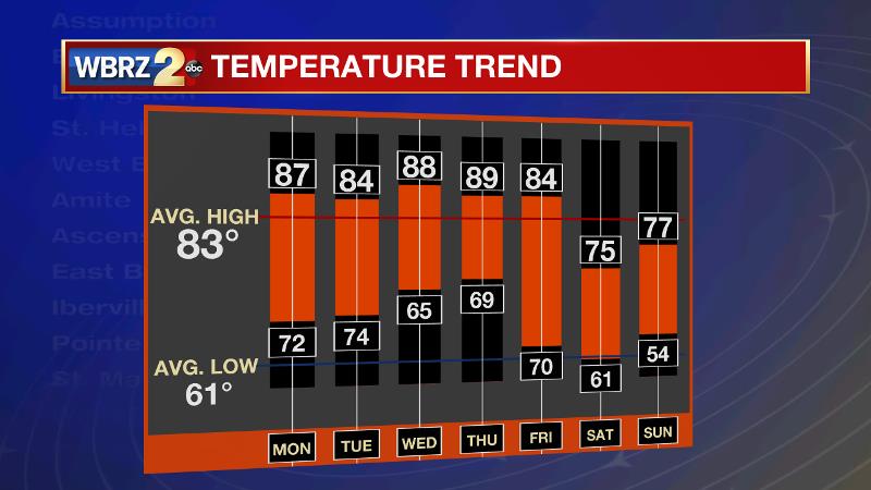
Up Next: On Tuesday, high temperatures will still be above average, but considerably cooler. Expect clear skies behind the front on Tuesday and Wednesday, but the front will rebound north as a warm front into Thursday. This will bring isolated showers and thunderstorms back to the forecast. A stronger cold front will then move through the area Friday and early Saturday. After another round of showers and thunderstorms, a punch of crisp air will deliver a fall feel into the weekend. At this time, expect highs in the 70s and lows in the 60s and even 50s for the upcoming weekend.
Trending News
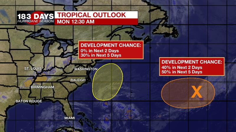
The Tropics: A non-tropical low pressure system is expected to develop along a frontal boundary over the central Atlantic Ocean between Bermuda and the Azores by Monday night. Gradual development of this system is possible while it moves slowly westward. The National Hurricane Center gives this disturbance a 50 percent chance of tropical or subtropical depression formation Tuesday or Wednesday. Another non-tropical low pressure system is forecast to develop over the western North Atlantic between Bermuda and the east coast of the United States in a few days. The low could acquire some subtropical characteristics later in the week and is given a 30 percent chance of development.
THE EXPLANATION:
A cold front will move southward across Louisiana and Mississippi on Monday. High temperatures will remain above average prior to its arrival. The boundary should arrive in the Baton Rouge area during the mid to late afternoon hours. Ahead of it, showers and thunderstorms are expected to develop but not all locations will receive rain and those that do will not get enough to put a major dent in the dry spell we have had of late. Rain will end from north to south with dry air pushing in this evening as winds turn northerly. Cool air advection will establish overnight and low temperatures will settle into the mid 60s by Tuesday morning. Tuesday will be seasonably warm with highs in the mid 80s but comfortable warmth with no significant humidity. Onshore flow will commence on Wednesday allowing moisture to return to the atmosphere. By Thursday, this will be enough to trigger isolated afternoon showers and thunderstorms. The next storm system will be a more significant cold front that is expected to bring a round of showers and thunderstorms late Friday followed by a Canadian based air mass. Timing with this front has been accelerated by forecast models, which would allow cool air and dry conditions to set up for the weekend. Highs and lows are expected to be 10 degrees below average behind this one.
--Josh
The WBRZ Weather Team is here for you, on every platform. Your weather updates can be found on News 2, wbrz.com, and the WBRZ WX App. on Apple and Android devices. Follow WBRZ Weather on Facebook and Twitter for even more weather updates while you are on the go.
More News
