

Latest Weather Blog
Wednesday PM Forecast: record warmth to break with late week cold front
February 2023 was the 10th warmest on record in the Baton Rouge area, going back to 1892. Well above average temperatures will continue until a cold front storms through Thursday night into Friday.
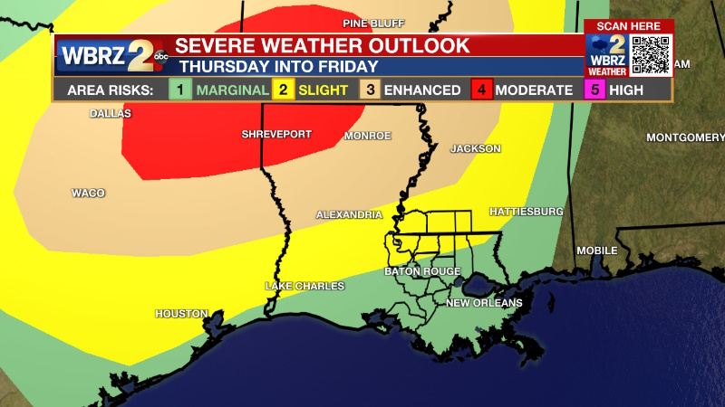
Tonight & Tomorrow: A low cloud deck is expected to thicken again overnight but winds out of the south at 5-10mph should prevent fog from forming. Low temperatures will stick near 70 degrees. Thursday will continue the warm pattern with highs in the upper 80s. Expect a breezy day with south winds increasing from 10 to 15 mph. The afternoon should remain partly sunny, though clouds may start to increase late as a cold front approaches from the west. A line of rain and thunderstorms is anticipated between 2am and 6am Friday morning. The best ingredients for severe weather will stay north and west of the Capital Area, but there will remain a chance for a gusty thunderstorm or two.
Up Next: On the other side of the front, skies will clear for the weekend with a three day stretch of dry and pleasant weather. Friday through Sunday expect lows near 50 and highs near 75. On Monday, a warm front will lift through the area with a sharp return in low level moisture. This combination could produce a stray shower, but rain is not a major factor in the forecast through the middle of next week. On the other side of that warm front, thermometers will climb again with highs and lows in the mid 60s and mid 80s, respectively.
Trending News
Get the latest 7-day forecast and real time weather updates HERE.
Watch live news HERE.
Detailed Forecast: Going into Thursday, attention turns to the west as a strong upper level trough of low pressure closes off over the Four Corners region and begins to move eastward into the plains. Out ahead of this feature, our upper pattern begins to transition to a moist, southwesterly flow. At the surface, a deepening low pressure is forecast to move quickly from the Plains into the Ozarks Thursday night and into Friday morning. The proximity of this low will result in plenty of directional shear out ahead within the moisture rich warm sector. During the day on Thursday and into the overnight, instability will be available. However, within the finer details there reside several limiting factors for our region. First, with the time day, a loss of warming overnight will cause some stabilization. Second, as the upper level trough rockets north and east, so does the best lift. Therefore, the loss of instability and exiting lift may cause a bit of a failure mode for severe weather. The event should not be written off though, the cold front itself should be able to produce enough forcing for a narrow band of showers and thunderstorms to come through the area early Friday morning. Enough wind shear will be present to produce an isolated strong to severe thunderstorm with gusty wind--especially north of the interstates. Behind the front, cooler and drier conditions will move into the region on Friday and into the start of the weekend. Winds will be gusty just prior to and after the frontal passage with some gusts nearing advisory criteria. The air mass is mostly Pacific in nature so no extreme cool down...in fact it appears that temperatures will remain around average. Going into the weekend and beyond, the normal temperatures will not last long as the upper levels warm once again resulting in above average temperatures early next week.
--Josh
The Storm Station is here for you, on every platform. Your weather updates can be found on News 2, wbrz.com, and the WBRZ WX App on your Apple or Android device. Follow WBRZ Weather on Facebook and Twitter for even more weather updates while you are on the go.
More News
