

Latest Weather Blog
Sunny and steamy with poor air quality, then tropical rain possible
Through Thursday, steamy and mainly dry weather is expected. The forecast focus will be on the tropics as a disturbance could bring heavy rain by the weekend.
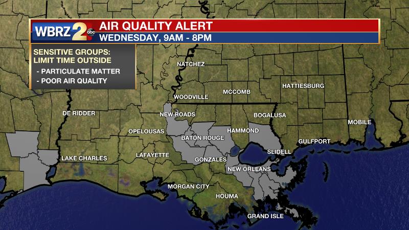
Next 24 Hours: The latest crop of showers and thunderstorms will diminish this evening. The rest of the night will be mostly clear with lows in the mid 70s. Wednesday will be mostly sunny, hot and humid with highs in the mid 90s and feels-like temperatures in the 105-110 range. A stray shower is possible, but unlikely. There is also an AIR QUALITY ALERT for the Baton Rouge Metro Area on Wednesday. CLICK HERE to see who will be most affected and what you should do.
Up Next: Thursday should stay mainly dry with highs in the mid 90s and lows in the mid 70s. All eyes turn to the south by Friday. Regardless of an officially named storm, a plume of tropical moisture will move over the area. A period of wet weather is expected Friday afternoon through Sunday afternoon. As is the nature of tropical rainfall, it could be torrential at times. The current expectation is for about 5 inches of rain, but isolated amounts up to 10 inches could be possible. Of course, as a system has yet to develop, forecast confidence is lower at this time but will increase through the week. If you live in the Baton Rouge area, it will be important to get weather updates through the week. CLICK HERE for your full 7-Day Forecast.
Trending News
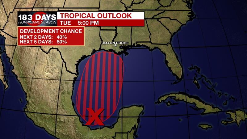
The Tropics: Disorganized showers and thunderstorms continue over the Bay of Campeche and southern Mexico in association with a broad area of low pressure. This system is expected to move very little during through Wednesday, and any development should be slow to occur during that time period due to its close proximity to land. However, the disturbance should begin to move northward by Thursday, and there is an 80 percent chance that a tropical depression will form late in the week when the low moves across the central and northwestern Gulf of Mexico.
Tropical Storm Bill is producing 60 mph winds, away from land, over the north-central Atlantic Ocean. The system is expected to become extratropical and then dissipate Wednesday or Thursday.
Shower activity is limited in association with a tropical wave located a few hundred miles south-southwest of the Cabo Verde Islands. There is just a 10 percent chance of development during the next couple of days while the wave moves westward. Thereafter, a combination of dry air aloft and strong upper-level winds should end the chances of formation.
For the latest forecast and preparation reminders, visit the WBRZ Hurricane Center as we navigate all 183 Days of Hurricane Season.
The Explanation: The middle of the week will be warm and mostly dry as the eastern perimeter of an upper level ridge nudges overhead. This ridge will increase sinking air processes, which contribute to warming temperatures and work against convective development. Additionally, sitting on the eastern fringes of the ridge, upper level winds will be out of the north and drier. While this works to suppress showers and thunderstorms, any updrafts that can form could tap into this dry air to create gusty wind in any rogue thunderstorms. That is just something to be aware of even though Wednesday and Thursday will be mostly dry. Into Friday, all forecast focus will be on the tropics. Confidence is low in the eventual development, track or strength of a tropical system. However, confidence is higher that the eventual evolution of this system will lead to increasing moisture in the atmosphere over the local area, which will lead to a period of wet weather. By Friday, showers and thunderstorms will develop across the area in response to increased moisture and lift in the environment on the northern fringes of the tropical disturbance. Even if it is a messy, poorly organized system, it is expected to be slow moving enough to allow periods of rain to stay in the forecast through at least Sunday morning.
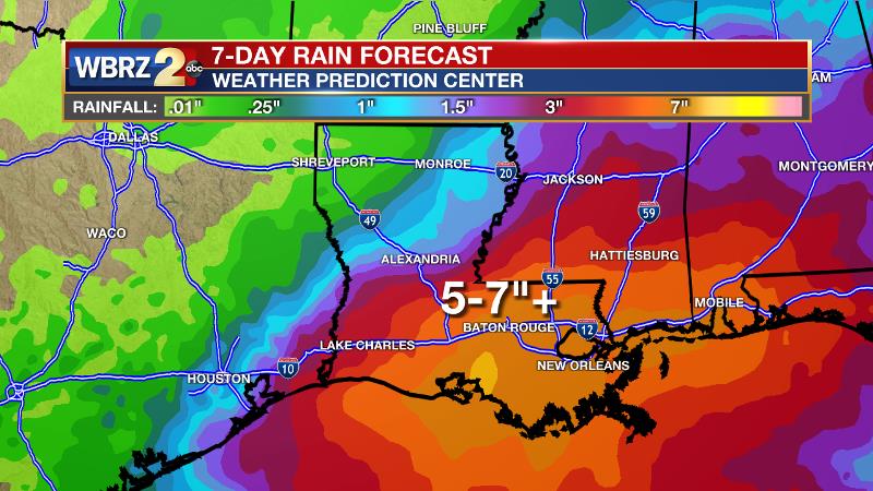
With near record moisture content in the atmosphere, rain could be very heavy at times and forecast models are pointing to 5 inches on the conservative end and 10 inches on the aggressive side. That alone should indicate that the local area should pay attention to the progress of this system and continue to get updates from our weather team.
--Josh
The WBRZ Weather Team is here for you, on every platform. Your weather updates can be found on News 2, wbrz.com, and the WBRZ WX App on your Apple or Android device. Follow WBRZ Weather on Facebook and Twitter for even more weather updates while you are on the go.
More News
