Sunday PM Forecast: Staying warm, another shot at rain & tropical mischief in the Gulf
The abnormally warm and humid conditions don't go anywhere this week. The Storm Station will also be tracking tropical mischief in the Gulf of Mexico and an approaching cold front which could deliver another round of rain.
Tonight & Tomorrow: Expect partly cloudy skies on Sunday night, along with a continuation of the humid and incredibly warm temperatures. Look for an overnight low in the low to mid-70s across the Capital Area. This is especially notable since the warmest low temperature on record for Monday (Nov. 4th) is 69°. Needless to say, the forecast low exceeds that record value by a wide margin. Record warmth is possible into the afternoon also. Highs will climb into the upper-80s in Baton Rouge on Monday, challenging the record high of 89° from 2016. A stray shower can't be ruled out as things heat up, but those will be the exception as opposed to the rule. It will otherwise be partly sunny.
Up Next: A cold front will approach on Tuesday. The problem is, it will stall to the west before ever getting a chance to pass through the Capital Area. Specifically on Tuesday, the nearby front will result in a uptick in shower and thunderstorm activity. But even so, what does develop will be widely scattered in coverage. Rain coverages will fall once again on Wednesday. And without a clean frontal passage, temperatures remain unseasonably warm both during the day and at night for the remainder of the workweek. It is not out of the question to see more records be challenged.
There are some question marks surrounding the forecast late this week. This is closely tied to the development and eventual track of a tropical disturbance which will enter the Gulf of Mexico around midweek (see the Tropics section below). At this point, the long-term track of what will soon become Rafael is unknown. But without a cold front to shield Louisiana from tropical impacts, the system will require close monitoring. Stay tuned to the latest forecast this week, as adjustments may or may not be needed closer to the weekend depending on the future track of Rafael. For now, the Storm Station 7-Day Forecast keeps things quiet.
Get the latest 7-day forecast and real time weather updates HERE.
Trending News
Watch live news HERE.
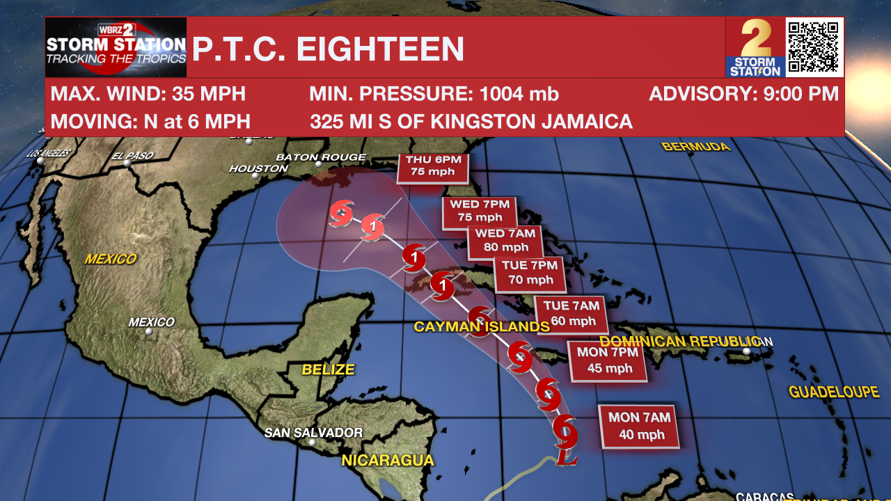
The Tropics: The National Hurricane Center began issuing advisories for Potential Tropical Cyclone (P.T.C.) Eighteen on Sunday afternoon. Remember that the "potential tropical cyclone" terminology is used when a disturbance has yet to acquire tropical characteristics, but could do so and affect land within 48 hours. This allows the National Hurricane Center to begin issuing tropical alerts before the system truly develops.
P.T.C. Eighteen will likely become a tropical storm on Monday. When that happens, it will take the name Rafael. The latest forecast has the storm reaching hurricane strength as it approaches Cuba. The storm is then projected to move northwestward into the Gulf of Mexico around midweek.
After moving into the Gulf, the steering currents rearrange in a fashion that could allow the system to slow down a meander temporarily. This introduces significant uncertainties to the long-term track forecasts. It is still too far out to know if and where impacts may set up along the Gulf Coast. From an intensity standpoint, the storm will encounter a more hostile environment in the Gulf which would limit additional strengthening.
It is worth noting that Louisiana has never experienced a landfall by a named system in the month of November. Should that occur, it would be unprecedented. But with a lack of cold fronts cleanly passing through to help shield the region from the system, it is worth monitoring.

Patty is another active system in the North Atlantic. The has exhibited subtropical characteristics for the past couple of days, meaning that it was a hybrid system gaining energy from warm ocean waters and warm/cool air contrasts. But on Sunday night, Patty became fully tropical and attained tropical storm status. However, that will be short-lived. Patty will become post-tropical in the next day or so. This system will not pose a threat to the United States.
Meanwhile, another area of disturbed weather is expected to develop near the northern Leeward Islands around the middle of the week. Slow development is possible thereafter as it moves generally westward over the southwestern Atlantic.
-- Meteorologist Malcolm Byron
The Storm Station is here for you, on every platform. Your weather updates can be found on News 2, wbrz.com, and the WBRZ WX App on your Apple or Android device. Follow WBRZ Weather on Facebook and Twitter for even more weather updates while you are on the go.


