

Latest Weather Blog
Sunday PM Forecast: Break out the jackets/coats as temperatures prepare to nosedive
A strong cold front arrives leading up to Halloween. Although rain chances are limited this go-round, look no further if you’re hoping for cooler weather. Temperatures fall through the day on Monday. On Halloween, temperatures may struggle to reach 60°. Overnight lows will be even cooler, with some venturing close to frost/freeze territory by mid to late week.
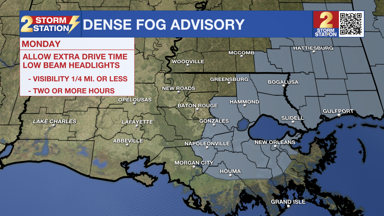
Tonight & Tomorrow: Clouds increase overnight Sunday, with skies eventually turning mostly cloudy early Monday. The arrival of a cold front and its associated increase in wind speeds will likely shut off the fog potential along and west of Baton Rouge on Monday morning. However, there is a window of opportunity to encounter patchy areas of dense fog to the east of the capital city. A Dense Fog Advisory will be in effect from 1-9 a.m. Monday for those parishes.
The cold front will pass through Baton Rouge closer to sunrise, setting us up for a significantly cooler day. Official high temperatures will likely end up in the lower-70s. However, that occurs around midnight. Afternoon temperatures will likely be stuck in the 60s, falling into the 50s by dinnertime. There will also be a noticeable increase in clouds, and we cannot rule out some spotty showers. These don’t look like big rainmakers, and we’re looking at a 20% rain coverage at best.
Up Next: For Halloween, we’ll keep a spotty shower chance in the morning. Clouds also hang around for most of the day, then begin to clear by evening. The chill remains too, with highs struggling to reach 60°. The trick-or-treaters will be facing temperatures in the low to mid-50s. Afterward, it gets even cooler. We’re forecasting low temperatures in the 30s both on Wednesday and Thursday. We will be watching the frost/freeze potential, especially on Thursday morning. Those in the capital area and areas north will need to watch this closely as we may need to take action to protect plants and pipes before the week’s end.
Trending News
Get the latest 7-day forecast and real time weather updates HERE.
Watch live news HERE.
The Tropics: As of Sunday afternoon, there are no active tropical systems in the Atlantic basin. However, we are watching a broad area of low pressure located a couple hundred miles east of the Bahamas. While conditions are not favorable for development, a short-lived tropical depression or storm isn’t out of the question during the next day or so. This system will soon be swept out to sea, with no threat to the United States.
There is another area of concern in the southwest Caribbean. Gradual development of this wave as it moves generally westward toward Central America. Chances of tropical development appear low in the next 7 days for now.
-- Meteorologist Malcolm Byron
The Storm Station is here for you, on every platform. Your weather updates can be found on News 2, wbrz.com, and the WBRZ WX App on your Apple or Android device. Follow WBRZ Weather on Facebook and Twitter for even more weather updates while you are on the go.
More News
