

Latest Weather Blog
High temps climb, "slight risk" Wednesday night
Temperatures will not change much this week. The next storm system to roll across our area will come Wednesday night.
THE FORECAST:
Today and Tonight: Skies will stay mostly sunny on Tuesday. High temperatures will climb a little higher into the low 80s. Overnight lows will be in the low 60s with some more clouds building.
Up Next: The next low pressure system is set to develop and pass to our north late Wednesday and Thursday, which will bring a return of showers and storms along the Gulf Coast. While considerably less robust than the last two systems, one or two storms could maintain some strength through the local area Wednesday night. The Storm Prediction Center has placed areas north and west of Baton Rouge in a 2/5 “slight” risk for severe weather. Storms should primarily come via a line and therefore damaging wind gusts and hail are the main threats. Another weak system is poised to move through over the weekend, but forecast models currently disagree on the amount of precipitation that occurs with that.
The Mississippi River: At Baton Rouge, major flood stage continues with a level of 43.5’ as of Tuesday morning. The river is expected to fall very slowly through the next two weeks. The high water is primarily an issue for river traffic and river islands, although some inundation will continue for a few spots north and south of Baton Rouge that are not protected by levees. Unprotected low-lying areas will be flooded and agricultural operations will be impacted on the west side of the river. The grounds of the older part of Louisiana State University's campus become soggy. This includes the area around the Veterinary Medicine building, the Veterinary Medicine Annex, the stadium and ball fields. The city of Baton Rouge and the main LSU campus are protected by levees at this level. The level is also high in New Orleans and the U.S. Army Corps of Engineers has opened the Bonnet Carre Spillway.
THE EXPLANATION:
The next, more substantial storm system will zip across the southern tier on Wednesday. This upper level trough will pull moisture northward through the day. By evening, a surface low pressure reflection will move across Arkansas and north Mississippi with a trailing cold front. This system will take a slightly more northern track, meaning the wind fields will not be quite as favorable for severe weather as the last system. Also, the nighttime passage will leave a little less warmth and instability as well. Still, enough ingredients are showing up on forecast model guidance that one or two strong thunderstorms will be possible, especially north and west of Baton Rouge.
Trending News
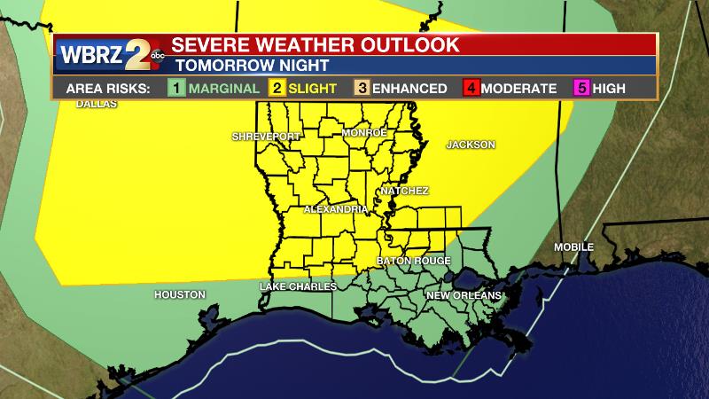
Therefore, the Storm Prediction Center has placed areas from Kentwood to New Roads and points north in a “slight” risk for severe weather. A squall line appears to be the most likely mode of this storm system and so damaging winds and hail are the main threats. If enough surface instability can linger overnight, a tornado will be possible too, but that threat is just conditional at this point. This system will exit on Thursday morning with quiet weather to follow until another weak disturbance arrives on Saturday. At this time, that one looks low impact.
--Josh
The WBRZ Weather Team is here for you, on every platform. Your weather updates can be found on News 2, wbrz.com, and the WBRZ WX App. on Apple and Android devices. Follow WBRZ Weather on Facebook and Twitter for even more weather updates while you are on the go.
More News
