

Latest Weather Blog
Thursday Evening Forecast
Related Story
Afternoon rain ending, expecting more showers in the forecast for tomorrow.
THE FORECAST
Tonight & Tomorrow: Showers and storms are beginning to wrap up across the Capital Area now. A second round of rain is possible later this evening but most will stay completely dry. Overnight cloud cover will linger into the morning hours and temperatures will fall into the mid-70s. Your Friday morning commute will likely be interrupted by rain. Shower and storm activity will ramp up early in the day and begin to decrease as we head into the afternoon hours. A blanket of clouds will hold our temperatures in the mid-80s. There will be times of sunshine and dry time during the day with some spotty showers. More of the same wet pattern is expected as we head into the weekend.
RIVER FORECAST-
— Jacelyn Wheat (@JacelynWheatWX) August 25, 2022
The Tickfaw at Montpelier and Holden and the Tangipahoa at Robert will crest just over minor flood stage this weekend.
All other rivers are expected to stay below flood stage. pic.twitter.com/SIFAOW7YiO
Up Next: Saturday morning will start off humid with partly sunny skies. Temperatures will begin to climb into the high-80s across the area. Warming temperatures and an abundance of moisture will help fuel some afternoon showers. As the sun begins to set shower activity will fizzle out and temperatures will cool into the mid-70s. No total washouts expected this weekend. Sunday looking a little drier, with mostly sunny skies at the start of the day. Cloud cover will begin to build in as the day goes on and more showers are possible in the afternoon hours. Temperatures will peak near 90 across the area. The wet pattern not letting up anytime soon. More rain is expected for the start of your work week. Click here to see the 7-day forecast.
Hour-by-hour weather tracking is available for your location on the WBRZ WX App on your Apple or Android device. Follow WBRZ Weather on Facebook and Twitter for even more weather updates and unique weather insight from the whole team!
In the Tropics:
The Storm Station is monitoring two areas of potential development in the tropics. Low chance of formation expected over the next 5 days.
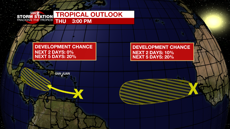
Near the Windward Islands:
A trough of low pressure located near the Windward Islands is
producing disorganized shower and thunderstorm activity. This
system is expected to move westward at about 15 mph during the
next several days, and environmental conditions could become more
conducive for slow development when it moves across the central and
western Caribbean Sea early next week.
* Formation chance through 48 hours...low...near 0 percent.
* Formation chance through 5 days...low...20 percent.
Eastern Tropical Atlantic:
A tropical wave located between the west coast of Africa and the
Cabo Verde Islands is producing a large area of disorganized showers
and thunderstorms. Environmental conditions could support some slow
development of this system through early next week while it moves
westward across the eastern and central tropical Atlantic at 15 to
20 mph.
* Formation chance through 48 hours...low...10 percent.
* Formation chance through 5 days...low...20 percent.
News
