

Latest Weather Blog
Sunday evening video forecast
Related Story
TONIGHT & TOMORROW
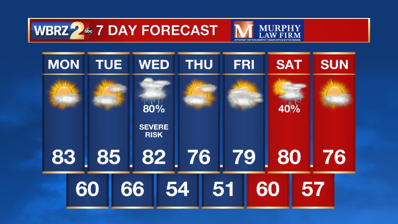
Overnight, we will have a few clouds overhead. Low temperatures will be nearly 10 degrees warmer compared to this morning - with most bottoming out in the mid 50s. There could also be patchy fog around, so be aware of that for your morning drive. Monday will feature mostly sunny skies with highs in the low and mid 80s. Winds will begin to pick up out of the southwest, between 10-15mph.
LOOKING AHEAD
Temperatures will continue to climb, with highs expected to warm into the mid and even upper 80s on Tuesday. This is all ahead of our next storm chance.
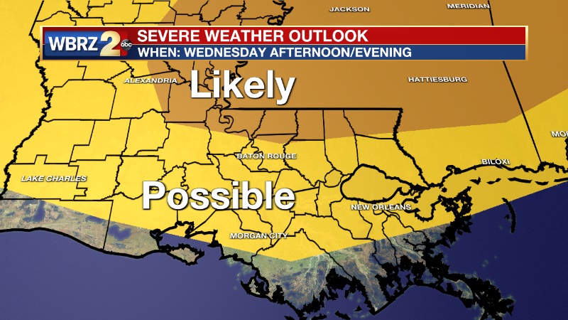
Another strong storm system will move in Wednesday bringing a chance for strong to severe thunderstorms. There is potential for an outbreak of severe weather with this event, but that may occur just north of the Baton Rouge metro. Still, a few strong to severe storms are possible in the area on Wednesday so we need to be prepared just in case. It is still too early to nail down the exact timing, but right now we are eyeing Wednesday afternoon and evening for the arrival of these storms. Tornadoes and damaging winds are likely the main concern.
It is spring time in south Louisiana and our main severe weather season - stay connected with us over the coming days for more updated details.
CLICK HERE TO DOWNLOAD THE WBRZ WEATHER APP
-- Meteorologist Jake Dalton
Your weather updates can always be found on News 2, wbrz.com, and the WBRZ WX App on your Apple or Android device. Follow WBRZ Weather on Facebook and Twitter for even more weather updates while you are on the go.
News
