

Latest Weather Blog
Wednesday PM Forecast: several chilly nights ahead
Rain is out of the forecast through the end of the week. A couple of cold nights, potentially near freezing, are expected.
Tonight & Tomorrow: Some passing clouds may continue to move across skies overnight, but the trend will be for clearing into daybreak. As winds remain out of the northwest at 10-15mph, low temperatures will dive into the mid 30s. Counties in southwest Mississippi will bottom around right around 33 degrees. Full sunshine is expected on Thursday. Despite this, a cooling northwest breeze of 5-10mph will continue and high temperatures will stop in the mid 50s.
Up Next: Friday morning will have the coldest temperature of the 7-Day Forecast with many lows close to freezing, especially north of Baton Rouge and the I-12 corridor. The current forecast for the city is 33 degrees. Obviously, that is close enough that you may want to make light freeze preparations on any sensitive outdoor plants. The afternoon will make it into the upper 50s with plenty of sun. Saturday is expected to stay dry but clouds will increase as rain showers are set to return for the second half of the weekend. A stalling front will move into the region on Sunday and bring periods of rain and a few thunderstorms. With that front meandering near the coast through at least early next week, scattered showers will likely remain in the forecast. Temperatures will be a bit warmer than average due to a moisture rich air mass staying in place along the front.
Get the latest 7-day forecast and real time weather updates HERE.
Watch live news HERE.
Trending News
Detailed Forecast: A strong surface high pressure system will move over the region into Thursday and remain through Friday. A bit of low level moisture could result in some passing clouds overnight Wednesday into Thursday but the strengthening area of high pressure will help to eliminate these clouds. Northwest winds will continue to push cooler and drier into the region through Thursday night. As winds go nearly calm at that point, low temperatures will fall close to freezing by Friday morning. A light freeze will be possible, especially north of I-12. The surface high will be east of the region by the weekend opening up the area to southeast winds and moist, onshore flow. Temperatures will increase back into the 60s.
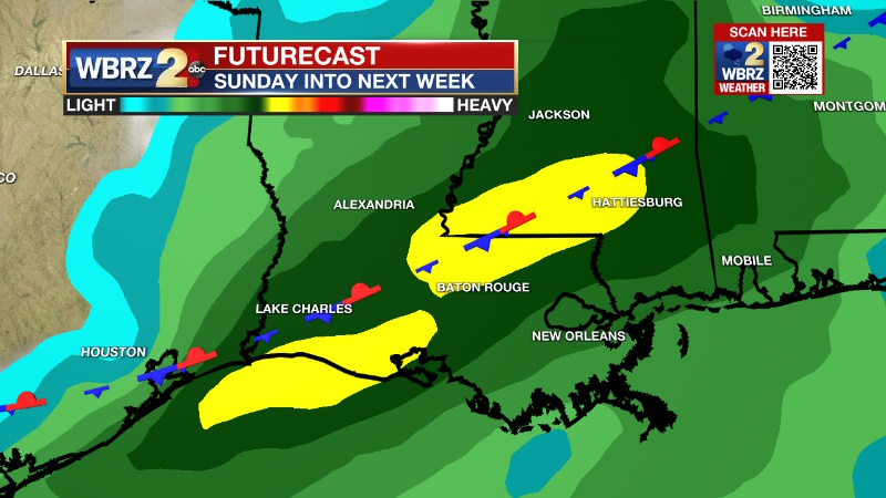
A weak, upper level trough of low pressure will move into the region on Saturday night. With favorable upper level winds over top of increasing moisture, widespread rain and a few thunderstorms can be expected on Sunday. A weak front will stall in the region since it will be essentially parallel to the upper level winds out of the southwest. With east to southeast low level winds, warm and moist air will be forced over the stalled front causing scattered showers to stay in the forecast through the early to middle part of next week. Since the front will not move far enough south for dry and cool air to move in behind it, the temperature forecast is difficult and numbers are generally expected to remain a few degrees above average by day and several degrees above average at night.
--Josh
The Storm Station is here for you, on every platform. Your weather updates can be found on News 2, wbrz.com, and the WBRZ WX App on your Apple or Android device. Follow WBRZ Weather on Facebook and Twitter for even more weather updates while you are on the go.
More News
