

Latest Weather Blog
Wednesday PM Forecast: scattered downpours continue chance for isolated flooding
The National Weather Service has continued the FLASH FLOOD WATCH through Friday for all local parishes and counties EXCEPT Amite, East Feliciana, Pike, Pointe Coupee and West Feliciana. Nicholas continues to slowly drift east near Lake Charles with copious amounts of gulf moisture continuing to stream into the area. Additional rain amounts of 2 to 5 inches with locally higher amounts are possible over the next several days.
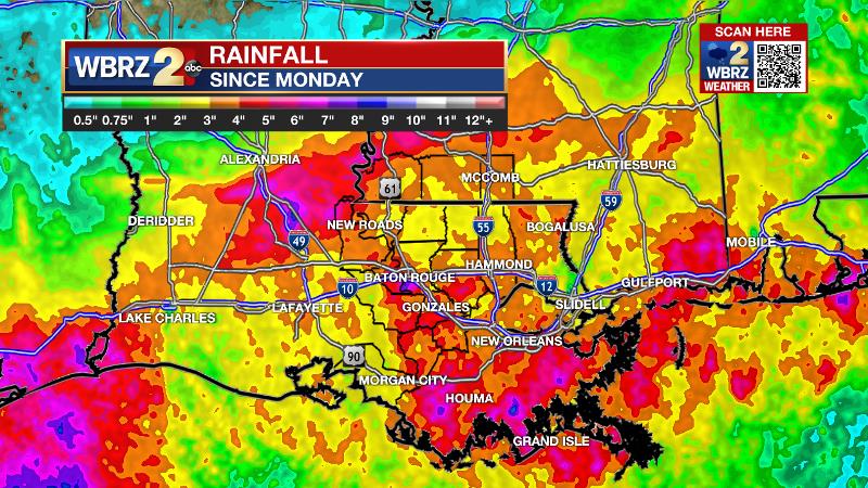
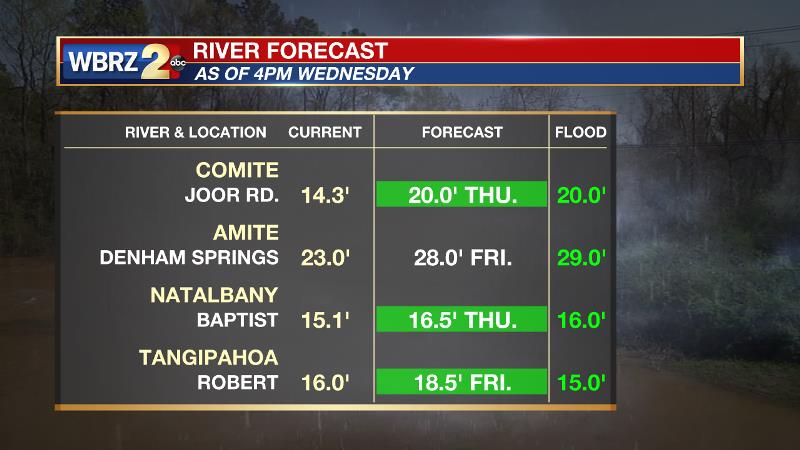
This will be on top of to the widespread 4 to 8 inches of rain that has fallen since Monday. The highly saturated ground will quickly lead to run off with drainage problems in areas still recovering from Hurricane Ida. Most local rivers have accepted the runoff well since rainfall has been spaced out over three days. Still, a few are expected to reach flood stage.
Trending News
Next 24 Hours: The overnight hours will be quieter than last but some rain stays in the forecast. Scattered showers will be possible through the night, however a constant rain is not expected. Low temperatures will stop in the low 70s. On Thursday, some sun may sneak out early in the day. High temperatures will respond to any dry time by reaching the low 80s. Especially with daytime warming, the remnants of Nicholas will trigger scattered to widespread showers and thunderstorms and any associated downpours could lead to isolated flooding issues.
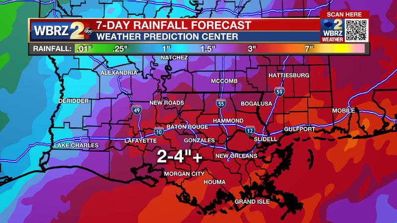
Up Next: Friday through Monday, the weather pattern will almost disguise as an active summertime setup. Leftover moisture from Nicholas and the associated upper level pool of unstable air will cause scattered showers and thunderstorms to develop each day as temperatures warm. Brief downpours will be possible. At this time, no washouts are expected, but many places could see some rain each day. The rain forecast through the middle of next week is 2 to 5 inches. A front will try to push into the area to flush things out by the middle of next week. CLICK HERE for your full 7-Day Forecast.
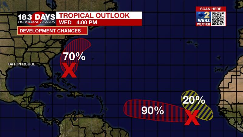
The Tropics: Showers and thunderstorms have changed little with an area of low pressure located a few hundred miles southwest of the Cabo Verde Islands. Environmental conditions are expected to remain favorable and there is a 90 percent chance that a tropical depression forms within the next couple of days while this system moves west-northwestward across the tropical Atlantic.
Satellite indicates that a low pressure system a few hundred miles northeast of the Bahamas is becoming better defined. However, associated showers and thunderstorms are still disorganized. Environmental conditions are expected to become more conducive for development, and there is a 70 percent chance that a tropical depression forms during the next day or two as the system moves north-northwestward off the southeast U.S. coast.
A tropical wave is expected to emerge off the west coast of Africa in a day or two. Thereafter, environmental conditions are forecast to support a 20 percent chance for development while the system moves generally west-northwestward over the far eastern Atlantic.
For the latest tropical forecasts, advisories and information, visit the WBRZ Hurricane Center as we navigate all 183 Days of Hurricane Season.
The Explanation: Through Friday, the remnants of Nicholas will hang up across south Louisiana. In the upper levels of the atmosphere, a weak trough of low pressure will center just west of the local area to allow increased lift. At the same time, total moisture content in the atmosphere, precipitable water, will remain well above average for the time of year. Especially when this lift maximizes Thursday night into Friday, the potential for heavy showers will continue. While the activity may present more scattered in nature on radar, downpours on top of saturated soils could quickly lead to flooding issues. Over the weekend and into early next week, an upper level trough will remain close enough to the area to maintain instability while tropical moisture continues to linger. As the remnants of Nicholas continue to dissipate, daytime warming may become the primary force in triggering showers and thunderstorms. By Wednesday, a cold front may finally approach from the north. It’s still early in the season for guaranteed cold fronts, but if this one can come through, it should provide enough dry air to finally quiet the wet pattern.
--Josh
The WBRZ Weather Team is here for you, on every platform. Your weather updates can be found on News 2, wbrz.com, and the WBRZ WX App on your Apple or Android device. Follow WBRZ Weather on Facebook and Twitter for even more weather updates while you are on the go.
More News
