

Latest Weather Blog
FLOOD WARNINGS issued, storms will push eastward
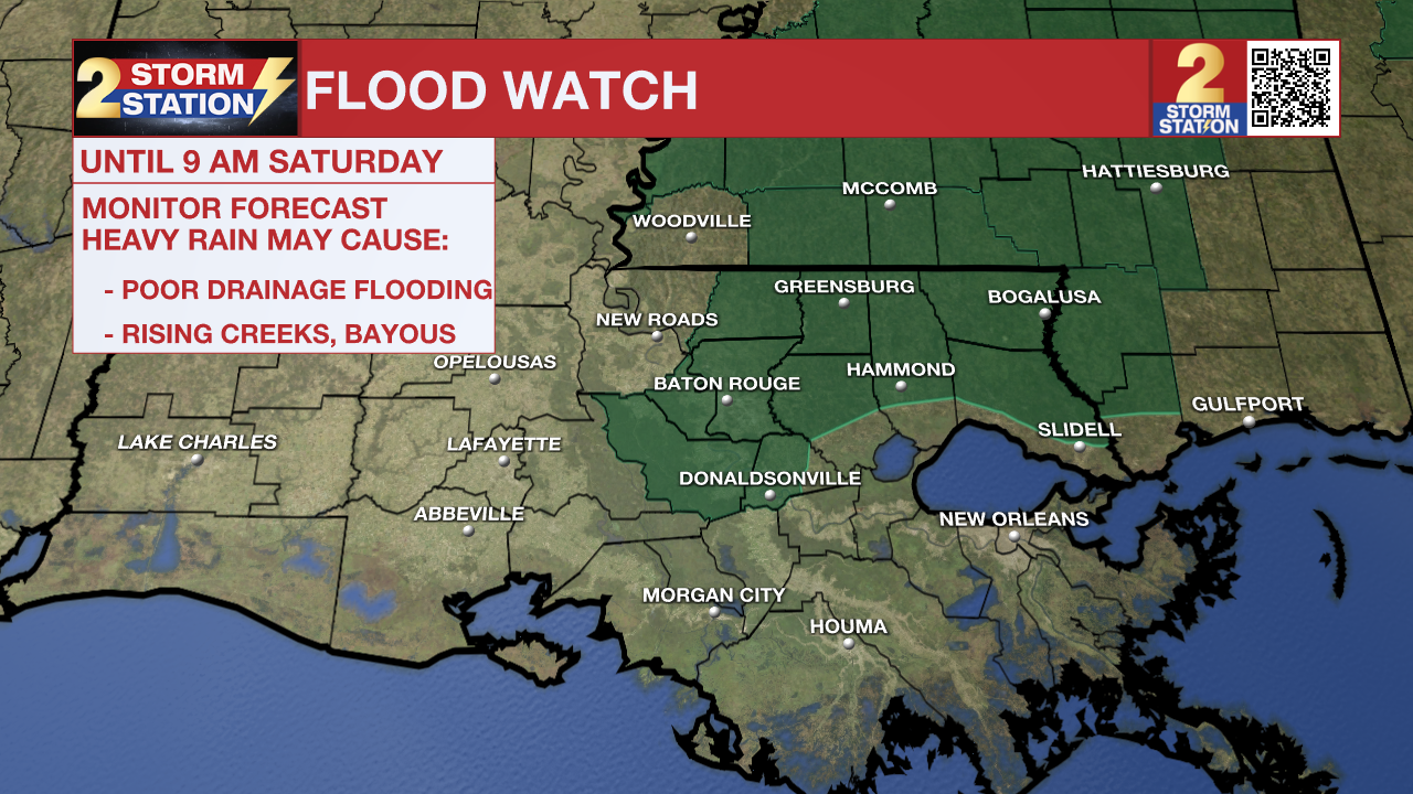
UPDATE - 5:30 a.m. Saturday: The National Weather Service has trimmed the FLOOD WATCH to now only include East Baton Rouge, West Baton Rouge, Upper Ascension, Iberville, East Feliciana, Northern Livingston, St. Helena, and Northern Tangipahoa Parishes, in addition to Amite County, until 9 a.m. Saturday. These locations are dealing with a line of repeating overnight thunderstorms, following Friday's rain, which saturated soils in the same region. With an additional inch or two of rain possible through Saturday morning, excessive runoff may result in flooding of rivers, creeks, streams, and other low-lying and flood-prone locations. Flooding may occur in poor drainage and urban areas. For more on flooding safety, CLICK HERE.
Check out the latest live radar below. Storm coverage increased after midnight, but fortunately, all have remained below severe limits as of 5 a.m. Saturday.

There remains a TORNADO WATCH in effect Amite and Wilkinson Counties until 10 a.m. Saturday. As storms continue to move northeast through the night, one or two might be capable of producing a brief spin-up tornado.
A TORNADO WATCH means conditions are favorable for tornadoes and/or damaging winds in and around the watch area. Be on the lookout for threatening weather conditions and listen for later statements and possible warnings. If a tornado warning is issued, seek shelter in a low-level, interior room of a sturdy building. Take pets (on a leash) with you, have on hard-soled shoes, monitor storm coverage on a wireless device, and cover your head in the event of wind or tornado impact. For more on tornado safety, CLICK HERE.
Trending News
- Click HERE to watch WBRZ streaming live online
- Click HERE for the WBRZ weather page.
- Click HERE to see how to download the WBRZ weather app.
An approaching cold front will bring periods of rain and thunderstorms to the Capital Area through Saturday morning. Some of the storms could be heavy and strong. Much cooler air will follow.
Into Saturday: A cold front will start to press on the Capital Area on Saturday morning. One final push of showers and thunderstorms will accompany this front, likely in some form of squall line. This round will also be capable of gusty winds and downpours. By late morning and early afternoon, rain will taper, and winds will turn northerly, dragging temperatures down through the 60s during the day. Clouds will remain fairly persistent.

Use the slider to advance through the next 24 hours of Futurecast

Up Next: Clouds will linger into Sunday. You will feel much cooler temperatures in the low 40s at dawn and upper 50s in the afternoon. Skies are not expected to fully flush clouds through the first half of next week. A mix of thick high clouds and a few low clouds may occasionally give way to some breaks of sunshine. Regardless of clouds, cooler-than-average temperatures will continue. A reinforcing shot of cold air will even come in on Wednesday, with a few freezing mornings possible toward the end of next week and next weekend.
Remember that the WBRZ WX App. is *free* on Apple and Android devices and can be used for breaking weather information, live radar, and forecast details. You can also use it to watch live coverage if power or broadcast signal is ever lost. For even more, connect with the Storm Station on X and Facebook. Stream WBRZ+ for continuous information as it becomes available.
— The Storm Station Meteorologists
The Storm Station is here for you, on every platform. Your weather updates can be found on News 2, wbrz.com, and the WBRZ WX App on your Apple or Android device. Follow WBRZ Weather on Facebook and X for even more weather updates while you are on the go.
More News
