

Latest Weather Blog
THE LATEST: Arthur, heavy rain threat, river levels and forecast
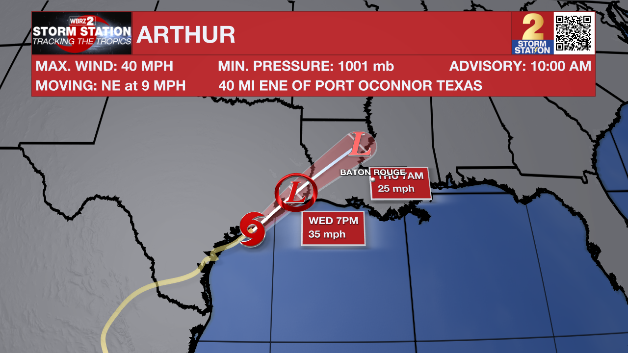
UPDATE: Now emerging off the Texas coastline, Tropical Storm Arthur has officially formed, making it the first named storm of the 2026 Atlantic hurricane season. Tropical Storm Warnings remain in place along the central Gulf Coast, extending from the east Texas coastline to St. Mary Parish. More information on Tropical Storm Arthur can be found in The Tropics section below.
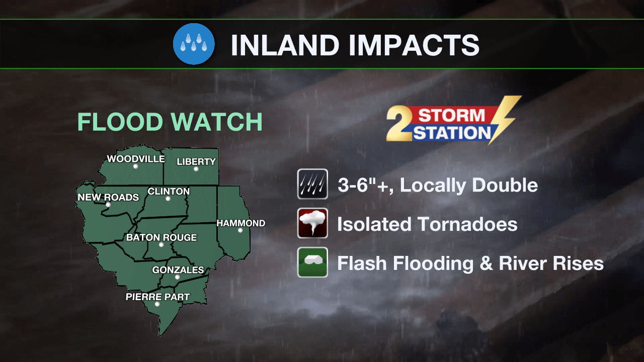
A FLOOD WATCH remains in effect for the entire Capital Region through Friday morning. A FLASH FLOOD WATCH means conditions may develop that lead to flash flooding. Flash flooding is a very dangerous situation. Be on the lookout for threatening weather conditions and listen for later statements and possible warnings. For more on flooding safety, CLICK HERE.
Widespread additional amounts of 3-6 inches of rain with “streaks” of 6-12 inches are likely. If those amounts occur in our cities rather than open marsh or swamp land, it will trigger significant poor drainage and river flooding.
Trending News
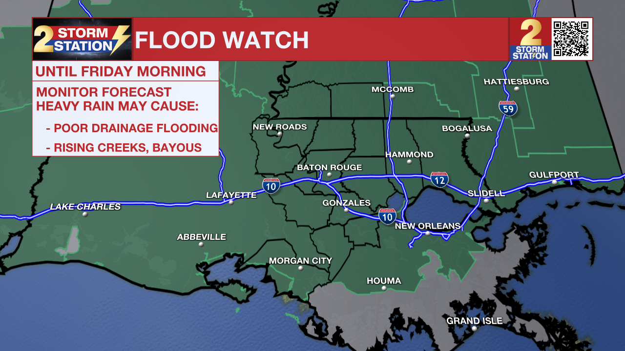
Tonight and Tomorrow: This evening and overnight will have very impactful weather. Heavy, tropical rain bands will move inland as Tropical Storm Arthur makes landfall in southwest Louisiana. Rain will be likely most of the night. Rates will be incredibly high in some places, and could quickly lead to flash flooding. Driving will be dangerous overnight, and the morning commute will be messy in the hardest-hit areas. Prepare for much slower drive times and the possibility of flooded roadways. In addition to the heavy rain, circulation associated with the tropical storm could also lead to an isolated, brief tornado. Thursday, more and more breaks in rain can be expected through the day. To be clear, though, scattered showers and thunderstorms will remain possible and capable of heavy rain in a short time. Occasional breaks of sunshine will help highs into the upper 80s, and it will still feel very humid in the leftover tropical air mass.

Use the slider to advance through the next 24 hours of Futurecast
Up Next: On Friday, the tropical system will finally pull away to the east. Scattered showers and thunderstorms will develop due to lingering tropical moisture. Expect a slow, gradual lowering of daily rain coverage with the pattern moving back toward daytime warming pop-up thunderstorms over the weekend. Humidity will stay in place and highs will return to the 90s.

Get the latest 7-day forecast and real-time weather updates HERE.
Watch live news HERE.
The Tropics: The low-pressure system near the Middle Texas coast has been upgraded to Tropical Storm Arthur, with sustained winds of 40 mph confirmed by buoy, ship, and aircraft data. Arthur is currently accelerating northeastward and is forecast to track along or over the Texas coast today before moving inland over southeastern Texas and southwestern Louisiana tonight. Due to strong westerly wind shear and land interaction, significant strengthening is unlikely; the storm’s tropical-storm-force winds remain confined to its eastern side over offshore waters, and Arthur is expected to weaken and dissipate by tonight. Heavy rainfall and life-threatening flash flooding remain the primary hazards.
River Flooding: With recent heavy rain and more storms on the way, several local river gauges are forecast to rise. To track conditions, find the latest river levels and forecasts below, updated twice every hour.


— The Storm Station Meteorologists
The Storm Station is here for you, on every platform. Your weather updates can be found on News 2, wbrz.com, and the WBRZ WX App on your Apple or Android device. Follow WBRZ Weather on Facebook and X for even more weather updates while you are on the go.
More News
