

Latest Weather Blog
Sunday PM Forecast: Dense fog starts the week, midweek rainmaker to break warm spell
A moisture-loaded ground will trigger dense fog across the area on Monday morning. Once that burns off, the warm and muggy pattern will continue. The next big rainmaker around midweek will seek to end the warm spell, with a noticeable cooldown trailing close behind.
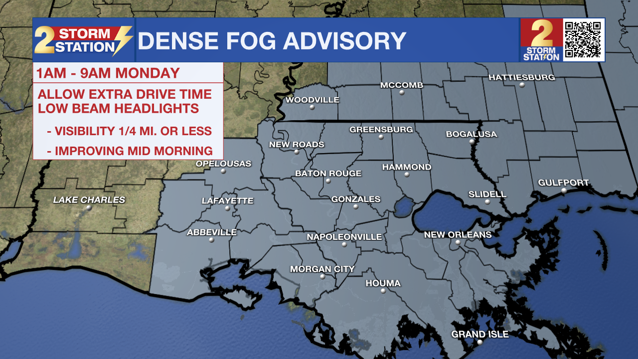
Tonight & Tomorrow: A quieter night is ahead after the recent soaking rain. While spotty evening showers cannot be ruled out, they remain the exception rather than the rule and will wrap up shortly after dusk (which now falls in the 7 o’clock hour following the time change). Clouds will increase as the night progresses, leading to an overcast sky by daybreak with lows in the mid to upper 60s. With saturated grounds, the abundant moisture will trigger areas of dense fog for the Monday morning drive. A Dense Fog Advisory will be in effect from 1 a.m. until 9 a.m. Monday for the entire Capital Area. If commuting during this window, remember to slow down, use low-beam headlights, and allow for extra travel time.
Morning clouds will eventually give way to partial afternoon clearing, allowing temperatures to sneak into the mid-80s as the sun emerges. The warming may trigger a handful of isolated showers; however, coverage will be relatively sparse.
Up Next: Another increase in clouds at night will result in a gray start on Tuesday. These clouds may be tough to break on Tuesday, but even so, expect a warm afternoon in the 80s with rain hard to come by. Another ramp up in rain chances will come around midweek. Scattered showers and storms on Wednesday afternoon will give way to a widespread line of storms after dark as a cold front marches into the region. A handful of stronger storms will be possible along this line, so be sure to remain weather-aware and alert to any potential warnings. Rainfall on the order of around 1” is the expectation. While the overall setup isn’t as favorable as this past weekend, localized higher totals could lead to temporary flooding in low-lying and poor drainage areas.

Conditions will quickly dry out as a cold front sweeps through the region early Thursday. The cooldown that accompanies it will be noticeable. Highs will struggle to reach 70° on Thursday, with lows dropping into the 40s early Friday. Another warmup will commence thereafter, with lows returning into the 50s with highs in the 80s next weekend. With plenty of sunshine, the weather will be perfect for the Wearin’ of the Green parade on Saturday.
Trending News

Get the latest 7-day forecast and real-time weather updates HERE.
Watch live news HERE.
— Meteorologist Malcolm Byron
The Storm Station is here for you, on every platform. Your weather updates can be found on News 2, wbrz.com, and the WBRZ WX App on your Apple or Android device. Follow WBRZ Weather on Facebook and X for even more weather updates while you are on the go.
More News
