Saturday PM Forecast: Heat is here, but a change of pace is coming for Sunday
Good news... some afternoon showers will cool us down a bit tomorrow!
THE FORECAST
Tonight & Tomorrow: The Heat Advisory in effect for the Capital Area will expire tonight at 7 PM. Temperatures will start to cool off into the high 70s tonight. Waking up to sunny skies and warming temperatures on Sunday. Temperatures will rapidly rise into the mid-90s. Feels like temperatures will rise into the triple digits but the heat will not be as intense as what we have been seeing this past week. Widespread showers will be sneaking in during the afternoon hours providing some relief from the heat. Sunday will not be a total washout but more people will see showers.
Sun and Heat Safety: Some friendly reminders for your summer of fun events—sunburn can occur in less than 15 minutes with the extreme U.V. Index typical of this time of year. In addition to that, heat exhaustion and heat stroke can set in just as quickly. Seek medical attention if you or somebody you know is affected. While we all enjoy a list of cool beverages, be sure water is at least a part of that list! Finally, look before you lock. DO NOT leave people or pets in an unattended car.
Up Next: Monday the more seasonable pattern continues. Temperatures will still be trending warmer than the average of 91°. Daytime highs will peak in the low 90s. Lots of available moisture in our atmosphere will allow for feels like temperatures to stay on the warmer side. More cooling afternoon showers will be sneaking into the forecast holding our temperatures to the mid-90s. Overnight temperatures will bottom out in the mid 70s. We will be waking up Tuesday morning to some muggies and clouds. The rest of the work week we will see this pattern continue.
Although we are seeing a break from the intense heat as we head into next week, our warm streak could still make this one of the hottest Junes on record. Click HERE to find out more on what this hot June could mean for July and August.
Trending News
Click here to see the 7-day forecast.
Hour-by-hour weather tracking is available for your location on the WBRZ WX App on your Apple or Android device. Follow WBRZ Weather on Facebook and Twitter for even more weather updates and unique weather insight from the whole team!
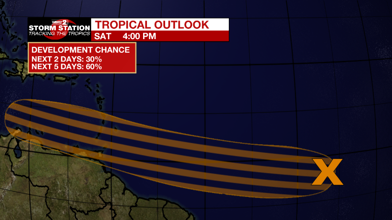
In the Tropics:

The low-level wind field associated with a tropical wave located
over the central tropical Atlantic Ocean has become better defined
today, but the wave is only producing limited shower activity.
Environmental conditions appear conducive for development of this
system over the next few days, and a tropical depression could form
during the early to middle part of next week. This system is
forecast to move westward at 15 to 20 mph over the tropical
Atlantic, approach the Windward Islands on Tuesday, and move across
the southern Caribbean Sea on Wednesday and Thursday.
* Formation chance through 48 hours...low...30 percent.
* Formation chance through 5 days...medium...60 percent.

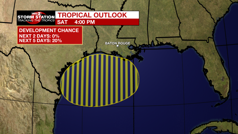
Northwestern Gulf of Mexico:
An area of low pressure could form early next week over the northern
Gulf of Mexico. Any development of this system would likely be slow
to occur as it drifts westward across the northwestern Gulf of
Mexico.
* Formation chance through 48 hours...low...near 0 percent.
* Formation chance through 5 days...low...20 percent.


