

Latest Weather Blog
Pattern gets wetter this weekend, watching two tropical disturbances
Typically, by this time in June there have been some stretches of hot, mainly dry weather. That has not been the case in 2021 and the pattern may only change for the wetter by Independence Day Weekend.
Next 24 Hours: Showers will dissipate after midnight, if not earlier. Skies will be partly cloudy into the morning with low temperatures in the low 70s. Wednesday will be partly sunny with temperatures warming into the upper 80s and low 90s before the southeast to northwest moving sea breeze fires off scattered showers and thunderstorms.
Up Next: Scattered showers and thunderstorms will stay in the forecast each day through the week. Highs will be about two degrees either side of 90 depending on when the cool down showers fall over your location. By the weekend, a cold front will move into north Louisiana and central Mississippi. With deep, tropical moisture pooling south of it, the boundary will be responsible for an uptick in showers and thunderstorms. Though it is a little early to call the weekend a washout, multiple rounds can be expected each day. Some downpours and therefore localized flooding could become an issue. At this time, 2 to 4 inches of rain are expected through next Monday. CLICK HERE for your full 7-Day Forecast.
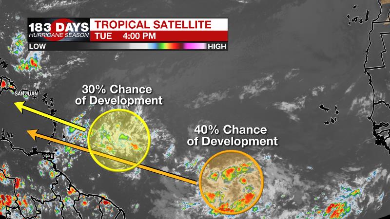
The Tropics: Disorganized showers and thunderstorms continue in association with a tropical wave located about 650 miles east of the Lesser Antilles. There is a 30 percent chance of development later this week while the system moves westward to west-northwestward at 20mph.
Trending News
Shower activity associated with a tropical wave located about 900 miles southwest of the Cabo Verde Islands continues to show signs of organization. There is a 40 percent chance of development during the next several days as it moves generally west-northwestward at about 20 mph.
For the latest tropical forecasts and information, visit the WBRZ Hurricane Center as we navigate all 183 Days of Hurricane Season.
The Explanation: A strong surface high pressure system will remain just offshore of the Northeastern U.S. through the week thereby maintaining deep southeast to northwest wind flow at the surface. This result of this “fetch” will be plenty of tropical moisture and a busy sea breeze to instigate showers and thunderstorms each day as temperatures warm. A typical daily rhythm of late morning to late afternoon showers and thunderstorms is expected each day through the week with daily coverage between 40 and 60 percent across the 13 Parish, 3 County Forecast Area. The pattern will change into the upcoming weekend, but not for the drier. A deep trough will dig into the eastern third of the country by Friday sending a cold front into the Southeast. Unfortunately, we will see the associated showers and thunderstorms but not cooler temperatures. Given the positon of the upper level trough and the lift added to the atmosphere by it and the front, scattered to widespread showers and thunderstorms are anticipated over the Independence Day Weekend. Moisture in the atmosphere, measured by precipitable water, will be well above average and so downpours and localized flooding could become a concern. As of now, the 7-Day Rainfall Forecast calls for 2 to 4 inches, plus.
--Josh
The WBRZ Weather Team is here for you, on every platform. Your weather updates can be found on News 2, wbrz.com, and the WBRZ WX App on your Apple or Android device. Follow WBRZ Weather on Facebook and Twitter for even more weather updates while you are on the go.
More News
