

Latest Weather Blog
Off and on rain could fall heavily at times today
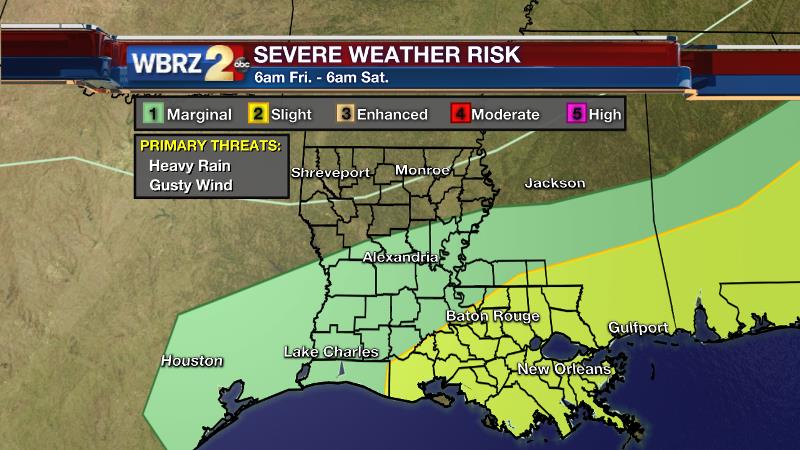
A *FLASH FLOOD WATCH* is in effect until 7pm Friday Evening for the entire WBRZ Weather Forecast area except St. Mary Parish.
Rain will be widespread today—meaning most locations, even those that have missed precipitation over the last two days, will have some action. The Wednesday and Thursday forecasts called for “scattered” showers and thunderstorms with the possibility of severe weather. This meant that not all areas were expected to see rain, but those that did could possibly have strong storms. Indeed that was the case, with golf ball-sized hail in Wilkinson County on Wednesday and an EF-1 tornado in St. Helena Parish on Thursday. The WBRZ Weather Team is proud to provide information to a 13 Parish, 3 County forecast area. We will continue to communicate weather forecasts, threats and protective actions in the most calm and forthcoming manner possible.
The Details:
Trending News
Today & Tonight: A cold front settling into Southeastern Louisiana and Southern Mississippi on Friday will offer the trigger needed to develop more widespread showers and thunderstorms. Downpours will be possible with any storms that develop. 1-3”+ of rain is expected by Friday Night. A storm with gusty wind or small hail can’t be entirely ruled out. High temperatures won’t warm beyond the low 70s. In fact, it wouldn’t be surprising to see thermometers trend down into the upper 60s during the afternoon. Overnight, rain will end with some clearing possible by morning. Winds shifting northerly will guide thermometers back into the mid 50s.
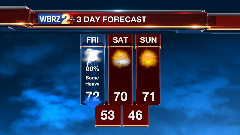
Looking Ahead: While some clouds could linger early, Saturday will turn sunny by afternoon with temperatures struggling for the low 70s. Expect light northeasterly winds to provide a cool feel and dry air. Sunday will begin in the mid 40s for most with ample afternoon sunshine returning afternoon highs to the low 70s. Mainly clear skies and slowly warming temperatures are on tap through Wednesday.
The Science:
Discussion: We’ve had a great recipe for unsettled weather the last few days, but nobody there to prepare the ingredients. Today, a top-notch chef rolls into town. As a cold front drops southeastward toward the Gulf of Mexico rain and thunderstorm coverage is expected to become widespread. The front will provide a forcing mechanism that has been lacking over the last few days and keeping precipitation isolated to scattered. Moisture will remain high ahead of and along the front, allowing storms to be efficient rain-makers. 1-3”+ with locally higher totals seems reasonable through the day, necessitating the FLASH FLOOD WATCH from the National Weather Service. There is still enough instability that with frontal lift gusty wind and small hail can’t be ruled out from a few storms. Once the front sags into the Gulf of Mexico on Friday Night, precipitation will end from northwest to southeast. With a flattening upper trough to the north and a rapidly weakening front, some cloud cover could linger into early Saturday until any inversion is busted by daytime warmth. With a surface high pressure building in from the northwest, northeasterly winds will transport cooler and drier air into the region. A chilly morning in the mid 40s is anticipated Sunday. As the high will be slow to move across the Gulf Coast and with dry air in place, expect larger diurnal temperature ranges with highs in the low to mid 70s and lows in the low to mid 50s through Tuesday. The next chance for rain shouldn’t come until Thursday, at the earliest.
Meteorologist Josh Eachus discusses the difficult forecast over the last three days and analyzes the transition from wet to dry between Friday and the weekend:
-Josh
Related Stories
More News
