

Latest Weather Blog
Front to cause wet weekend, new tropical system in the Atlantic
Alas, we have a pattern change to talk about. Additionally, there is a newly minted tropical system that will move into the Caribbean Sea this weekend.
Next 24 Hours: Showers will dissipate after midnight, if not earlier. Skies will be mostly cloudy into the morning with low temperatures in the low 70s. Scattered showers and thunderstorms will stay in the forecast through Thursday. Highs will be about two degrees either side of 90 depending on when the cool down showers fall over your location.
Up Next: By Friday, a cold front will move into north Louisiana and central Mississippi. With deep, tropical moisture pooling south of it, the boundary will be responsible for an uptick in showers and thunderstorms. Though it is a little early to call the weekend a washout, multiple rounds can be expected each day through Sunday. Some downpours and therefore localized flooding could become an issue. At this time, 2 to 4 inches of rain are expected through next Tuesday. The cold front will dissipate after that. The recent, regular pattern of late morning to late afternoon showers and thunderstorms will return for the middle of next week as we watch what is happening in the tropics to our east. CLICK HERE for your full 7-Day Forecast.
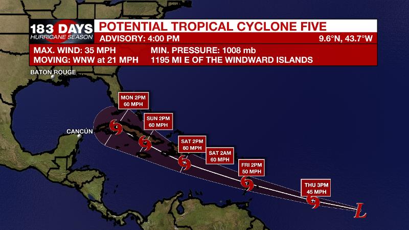
The Tropics: The National Hurricane Center has started issuing advisories for Potential Tropical Cyclone Five in the east-central Atlantic Ocean. While a tropical depression or tropical storm has yet to officially form, the potential tropical cyclone designation means the NHC believes a tropical system will form affect land soon.
Trending News
Showers and thunderstorms associated with a broad low pressure area and tropical wave located about 1300 miles east-southeast of the Windward Islands have become better organized since Tuesday. However, recent satellite wind data indicates that the disturbance does not have a well-defined circulation. Environmental conditions appear generally favorable for continued development, and a tropical depression or storm is likely to form during the next day or two while the system moves west-northwestward at 20 to 25 mph.
Parts of the Lesser Antilles are under a tropical storm watch as rain, wind and surge are possible in the next 48 hours. As the system enters the Caribbean Sea, a fast motion and interaction with the Greater Antilles may limit rapid strengthening, but an organized system should last into the weekend. Into next week, a gradual turn to the north near Cuba, and perhaps Florida, is expected. However, the track and intensity forecasts will become clearer over the next several days.
--Josh
For the latest tropical forecasts and information, visit the WBRZ Hurricane Center as we navigate all 183 Days of Hurricane Season. The WBRZ Weather Team is here for you, on every platform. Your weather updates can be found on News 2, wbrz.com, and the WBRZ WX App on your Apple or Android device. Follow WBRZ Weather on Facebook and Twitter for even more weather updates while you are on the go.
More News
