

Latest Weather Blog
Friday PM Forecast: rain, storms, sharp temperature drop start weekend
Friday morning shattered an old record warm low temperature in Baton Rouge at 72 degrees. The previous mark was 68 degrees in 2007. Then in the afternoon, Metro Airport also tied a record high at 82 degrees. Temperatures will take a big swing over the weekend.
Next 24 Hours: The overnight hours will remain mostly cloudy and breezy. Winds out of the southwest at 10-15mph will keep temperature steady in the low 70s. A few showers and thunderstorms could develop late, closer to dawn. Early Saturday, a strong cold front will push into the area with rain and thunderstorms. At this time, the threat for severe weather is low, but not zero. Any isolated strong storms could produce gusty wind. Even after the front passes, clouds and showers are expected to linger well into the afternoon. Winds will shift to the northwest and temperatures will fall out of the low 70s early and into the mid 50s by dusk.
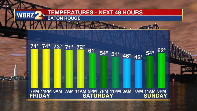
Up Next: Skies will clear out by Saturday night and allow full sun through Sunday. Look for one day of seasonable temperatures with lows in the low 40s and highs in the mid 60s. However, above average temperatures will quickly return and near record warmth is expected Tuesday through Friday next week with highs in the upper 70s and lows in the upper 50s. Mainly dry conditions will persist. CLICK HERE for your detailed 7-Day Forecast.
The Explanation: An upper level trough of low pressure will barrel across the central U.S. into Saturday. This trough is expected to be positively tilted, which means its center will be oriented from northeast to southwest, and therefore less favorable for severe weather. The basin of the trough will not even extend as far south as the Gulf Coast, which is another check against severe weather. The core of the jet stream, and very strong winds aloft needed for organized thunderstorms are likely to arrive later Saturday and that is yet another limiting factor. The main trigger for showers and thunderstorms will be the cold front associated with this system. Given the unfavorable time of day with minimum solar radiation, the most likely scenario is for a weakening line of showers and thunderstorms to drift across the region. As the front starts to parallel the upper level trough, it will slow through our area and result in showers lingering well into the afternoon. Temperatures will slowly fall through the day as well, from the 70s in the morning to the upper 50s by the evening. After a seasonably cool start to Sunday, thermometers will quickly begin to moderate. Next week, the Eastern U.S. will be dominated a very strong upper level ridge of high pressure. In fact, as the National Weather Service notes, the ridge could be two standard deviations above normal for the time of year. This means that our very warm December weather pattern will continue with high temperatures reaching the mid to upper 70s for most, if not all, of next week. In addition to the warmth, sinking air associated with the ridge will maintain a mostly dry weather pattern.
Trending News
--Josh
The WBRZ Weather Team is here for you, on every platform. Your weather updates can be found on News 2, wbrz.com, and the WBRZ WX App on your Apple or Android device. Follow WBRZ Weather on Facebook and Twitter for even more weather updates while you are on the go.
More News
