

Latest Weather Blog
Wednesday PM Forecast: heat continues, front to offer slight relief
A cold front is still advertised for the area on Thursday. While a cold front by definition, the only significant changes expected are mainly dry afternoons and lower humidity. Temperatures will remain warm.
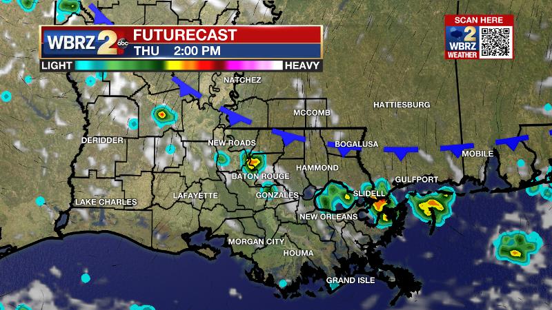
Next 24 Hours: A band of showers and thunderstorms may stretch across the area this evening. Activity will then break after midnight due to the loss of heat fuel. Low temperatures will stay uncomfortable in the mid 70s. High temperatures will peak near 90 on Thursday. With ample humidity, feels-like temperatures will be near 100 degrees. The National Weather Service has issued a HEAT ADVISORY with lower criteria than usual given the circumstances of no electricity, no air conditioning and the extra time being spent working outdoors. Through the day, a weak cold front will slide into the area from the northeast. This boundary will help to spark a couple of showers and thunderstorms—especially during the afternoon hours.
Up Next: The passage of that weak front will allow drier, less humid air to push in for Friday and the weekend. Since, dry air warm easier than humid air, high temperatures will remain warm in the upper 80s and low 90s but nights will be a bit more comfortable. Low temperatures will slip below average in the upper 60s and low 70s. Rain chances will be very low through Sunday. Another weak cold front will come into the region next week and stall. As a result, scattered showers and thunderstorms will return. CLICK HERE for your full 7-Day Forecast.
Trending News
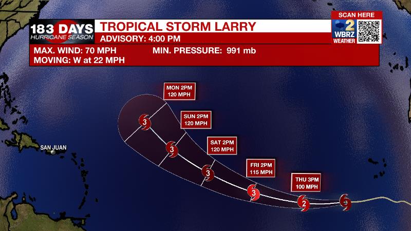
The Tropics: Tropical Storm Larry has been strengthening quickly. With maximum sustained winds of 70mph, it will become a hurricane by Thursday and a major hurricane by Friday. Moving to the west-northwest at 15-20mph, Larry is expected to slow down over the open, east-central Atlantic Ocean. Larry does not pose any threat to land at this time.
Recent satellite wind data indicated that the area of low pressure located in the southwestern Caribbean Sea has a well-defined circulation. However, shower and thunderstorm activity remains disorganized and displaced north of the center. There is a 30 percent chance of some development of this system over the next day or two if it remains over open water while moving west-northwest along the coast of Central America. By early next week, the system will have another opportunity for gradual development in the southwestern Gulf of Mexico.
For the latest tropical forecasts, advisories and information, visit the WBRZ Hurricane Center as we navigate all 183 Days of Hurricane Season.
The Explanation: While average heat and humidity for the time of year is anticipated through Thursday, the lack of air conditioning around the area will cause a greater likelihood of heat related illness. There the National Weather Service has issued heat advisories to heighten awareness. On Thursday, a weak cold front will move in from the northeast to spark a few more showers and thunderstorms. This feature should pass the local area with enough integrity to lower humidity as far south as I-10. On the other side of that front, an upper level ridge will center over the central Gulf Coast states and dew point temperatures will dip into the 60s. This will, decrease rain chances, and lower humidity. However, since drier air warms more efficiently than humid air, high temperatures may be warmer than earlier int he week and the afternoon heat index will end up nearly the same. Fortunately, overnight lows will be a few degrees cooler, around 70 degrees. Within the drier air mass, rain chances will be barely above zero through the weekend. Another week front is pegged to arrive early next week. Deeper moisture will pool ahead of it, returning humidity and elevating the chance of showers and thunderstorms.
--Josh
The WBRZ Weather Team is here for you, on every platform. Your weather updates can be found on News 2, wbrz.com, and the WBRZ WX App on your Apple or Android device. Follow WBRZ Weather on Facebook and Twitter for even more weather updates while you are on the go.
More News
