

Latest Weather Blog
Wednesday AM Forecast: The humidity will be dropping, lows will hit the 60s
We are front tracking! Very pleasant weather conditions are on the way.
THE FORECAST
Today & Tonight: Today a boundary will work its way through the area from northwest to southeast. It will spark up a few showers along the way this afternoon. About 30% of the area will see rain today. Between the showers, temperatures will max out in the upper 80s with the heat index just below 100 degrees. Areas that are largely without power are still under precautionary heat advisories through 5pm today. Temperatures tonight will drop into the very low 70s with some areas further north dropping into the 60s
Up Next: Throughout the day on Thursday, dry air will continue to settle in. This means that the humidity will drop and there will not be enough moisture for any rain. Afternoon temperatures will be in the 80s, but overnight temperatures will take a dip into the mid-60s Thursday night. Friday and Saturday will bring a lot of the same with temperatures in the 80s in the afternoon and overnight lows comfortably in the 60s. Starting Sunday the humidity will start moving back in. A few stray showers will be possible on Sunday. Next week we will return to the normal pattern, so enjoy the low humidity while we have it! Click here to see the 7-day forecast.
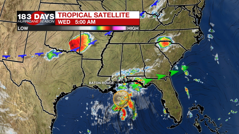
In the Tropics:
The disturbance in the Gulf will be pushed east by the front moving through our area today. It will not impact the local forecast.
Trending News
Disorganized cloudiness and a few thunderstorms over the central and eastern Gulf of Mexico are associated with a surface trough and an upper-level disturbance. The system is expected to move northeastward over the northeastern Gulf of Mexico later today. Upper-level winds could become slightly more favorable to support some tropical or subtropical development as the system nears the northern Gulf coast tonight or early Thursday. The disturbance is then expected to cross the southeastern United States, and some additional development will be possible after it emerges off the southeastern United States coast late this week. Regardless of development, areas of heavy rainfall will be possible across portions of the Florida panhandle and southern Georgia through Thursday, with localized flooding possible. There is a 50% chance of development in the next 2-5 days.
The WBRZ Weather Team is watching the tropics around the clock and will bring you updates as they come. Click here to visit the Hurricane Center.
Need weather conditions HOUR BY HOUR? Get hour by hour weather and right now weather conditions for your location on the WBRZ WX App on your Apple or Android device. Follow WBRZ Weather on Facebook and Twitter for even more weather updates and unique weather insight from the whole team!
More News
