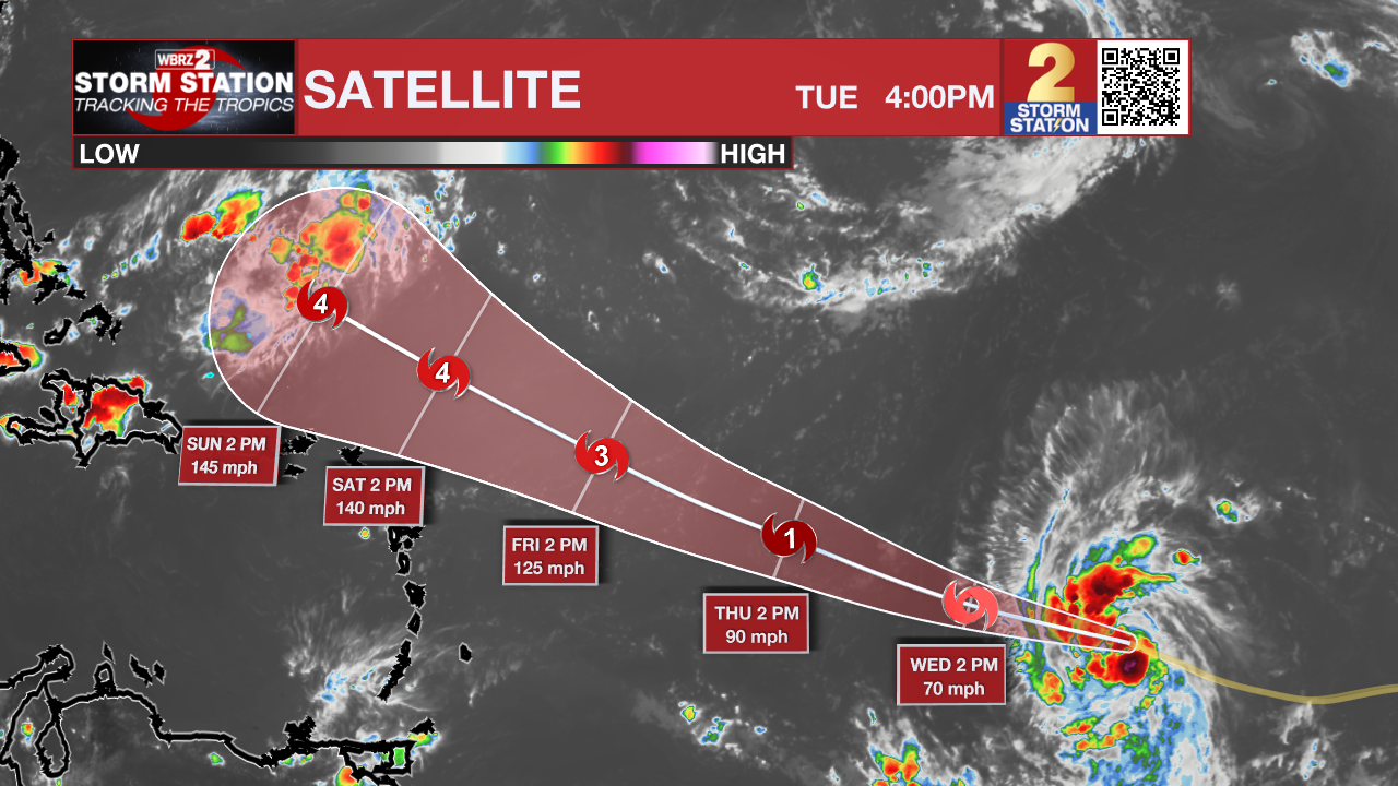
Tuesday PM Forecast: more 100s possible, Lee likely to be powerful hurricane in Atlantic
We will ride through the rest of the shortened workweek with hot temperatures and minimal rain. A weak front will move in for the weekend.
Tonight & Tomorrow: A couple of showers flared up on Tuesday afternoon but will fall apart into the evening hours. Low temperatures will stay above average in the upper 70s. Wednesday will be mostly sunny and mainly dry. High temperatures will surge into the upper 90s and with humidity, feels like temperatures will; go into the low 100s.
Up Next: Thursday and Friday will be rather hot. It is not out of the question that one or two spots scares up 100 degrees. All will make it into the upper 90s. Overnight low temperatures will be in the mid to upper 70s. As far as rain chances go, they are low but not zero. Especially late in the afternoon, some activity could push in from the northwest providing a stray shower. A weak front will dive south into the area on Saturday. This front is expected to stir up a few showers and thunderstorms. Changes on the other side will be minimal, but there could be a little lower humidity for the second half of the weekend. Looking at those first tailgates in Baton Rouge on Saturday, be prepared for a passing shower or thunderstorm, but there are no indications of a washout. Otherwise, it will be very warm and humid.
Get the latest 7-day forecast and real time weather updates HERE.
Watch live news HERE.
Trending News

The Tropics: Tropical Storm Lee formed in the central Atlantic Ocean on Tuesday. The system will continue to the west-northwest at 15mph and is expected to strengthen into Major Hurricane Lee in just a few days. At this time, there are no threats to land but the storm will need to be monitored along the East Coast into next week. It is not expected to enter the Gulf of Mexico.
A broad low pressure system associated with a strong tropical wave off the coast of West Africa, is producing a large area of showers and thunderstorms. Environmental conditions appear conducive for gradual development, and there is a seventy percent chance that a tropical depression could form over the far eastern tropical Atlantic during the middle to latter part of the week while the system moves west-northwestward at 10 to 15 mph.
Post-Tropical Cyclone Franklin is located a few hundred miles northeast of the Azores, and is forecast to move quickly east-southeastward towards warmer waters east of the Azores. This system could acquire some subtropical or tropical characteristics later this week or this weekend while it moves erratically between the Azores and Portugal.
--Josh
The Storm Station is here for you, on every platform. Your weather updates can be found on News 2, wbrz.com, and the WBRZ WX App on your Apple or Android device. Follow WBRZ Weather on Facebook and Twitter for even more weather updates while you are on the go.


