

Latest Weather Blog
Tropical Storm Wilfred named in the eastern Atlantic, T.D. 22 in the Gulf
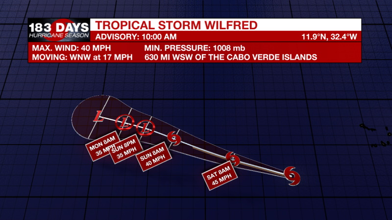
***UPDATE*** Tropical Storm Wilfred has formed in the eastern Atlantic. The maximum sustained winds are 40 mph and it is moving to the west- northwest at 17mph.
THE FORECAST:
Today and Tonight: Thick clouds will continue to build throughout the day today. Rain will be possible, but mainly for areas south of Baton Rouge. The cloud cover will prevent us from heating up too much, highs will be near 85 degrees. Overnight lows will be near 67.
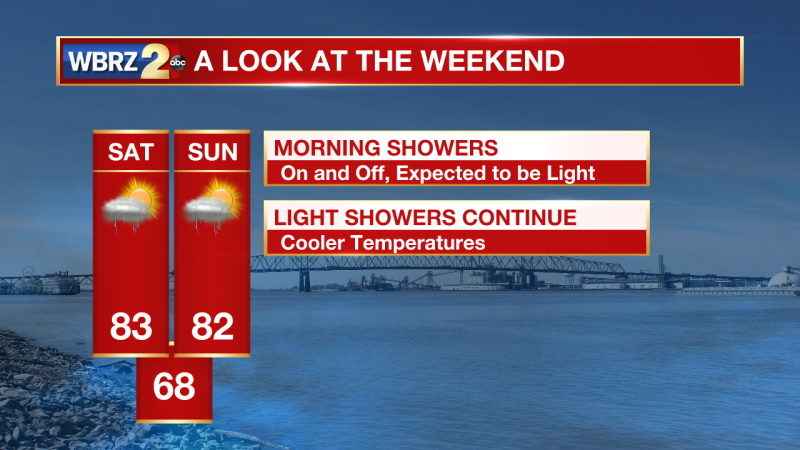
The Weekend: The weather conditions for the rest of the forecast are dependent on the behavior of a cold front and Tropical Depression 22 in the southwestern Gulf of Mexico. Starting Saturday morning, showers are likely to move north through our entire viewing area. You can expect to see light on and off rain on Saturday and Sunday. When it isn’t raining, there will be mostly cloudy skies. Temperatures will be held into the mid to low 80s in the afternoon hours and in the 60s overnight.
Next Week: Areas south of Baton Rouge will continue to have higher rain chances through much of next week. The forecast track for TD 22 for next week is very uncertain. Increased cloud cover and rain activity close to the coast are the main impacts through Thursday. High temperatures will be in the mid 80s and overnight lows will be in the upper 60s.
Trending News
TROPICAL UPDATE: TD 22 is forecast to move north through the Gulf of Mexico before taking a westward turn over the weekend. This system is expected to become a tropical storm later today. Since the name Wilfred has been taken, this storm will likely be the first of the Greek alphabet, Alpha.
Meanwhile, Hurricane Teddy reached category 4 strength and continues to move near Bermuda in the open Atlantic.
NHC FORECAST:
T.D. 22
At 1000 AM CDT (1500 UTC), the center of Tropical Depression Twenty-Two was located near latitude 23.8 North, longitude 93.9 West. The depression is moving toward the north-northeast near 7 mph (11 km/h), and this general motion is expected through early Saturday. A slow westward motion is forecast to begin late Saturday or Saturday night, and this motion will likely continue into early next week. Maximum sustained winds are near 35 mph (55 km/h) with higher gusts. Strengthening is forecast during the next few days, and the depression is expected to become a tropical storm later today. The system could be near or at hurricane strength by Sunday. The estimated minimum central pressure is 1005 mb (29.68 inches).
WILFRED
At 1100 AM AST (1500 UTC), the center of Tropical Storm Wilfred was located near latitude 11.9 North, longitude 32.4 West. Wilfred is moving toward the west-northwest near 17 mph (28 km/h) and this general motion is expected for the next few days. Maximum sustained winds are near 40 mph (65 km/h) with higher gusts. Some slight strengthening is possible today, and weakening should start this weekend and continue into next week. Tropical-storm-force winds extend outward up to 140 miles (220 km) from the center. The estimated minimum central pressure is 1008 mb (29.77 inches).
TEDDY
At 1100 AM AST (1500 UTC), the center of Hurricane Teddy was located near latitude 22.1 North, longitude 56.1 West. Teddy is moving toward the northwest near 12 mph (19 km/h), and this general motion is expected to continue for the next couple of days, followed by a turn toward the north by early next week. On the forecast track, Teddy will be approaching Bermuda late Sunday or Monday. Maximum sustained winds are near 130 mph (215 km/h) with higher gusts. Teddy is a category 4 hurricane on the Saffir-Simpson Hurricane Wind Scale. Some fluctuations in strength are expected during the next day or so, and a weakening trend is forecast to begin late this weekend. Hurricane-force winds extend outward up to 60 miles (95 km) from the center and tropical-storm-force winds extend outward up to 230 miles (370 km). The estimated minimum central pressure is 947 mb (27.97 inches).
AREAS TO WATCH
A small low pressure system located just west of the coast of Portugal is embedded within a larger non-tropical low. Although showers and thunderstorms associated with the smaller low are showing signs of organization, the system will soon move inland over Portugal and further tropical or subtropical development is unlikely. The low is producing gale-force winds, and will likely bring gusty winds and brief periods of heavy rain to portions of western Portugal today and tonight. For more information about potential hazards in Portugal, please see products issued by the Portuguese Institute for the Sea and the Atmosphere (IPMA). For more information about marine hazards associated with this system, see High Seas Forecasts issued by Meteo France.
* Formation chance through 48 hours...low...20 percent.
* Formation chance through 5 days...low...20 percent.
Post-tropical cyclone Paulette is located several hundred miles north-northwest of the Azores. The cyclone is forecast to move quickly southward for the next few days and then stall over marginally warm waters a few hundred miles south or south-southwest of the Azores by the end of the weekend. The cyclone could subsequently redevelop tropical characteristics late this weekend or early next week while it moves little.
* Formation chance through 48 hours...low...20 percent.
* Formation chance through 5 days...low...30 percent.
Another tropical wave is forecast to move off the west coast of Africa by early Saturday. Some gradual development of the system will be possible thereafter while it moves generally west-northwestward over the far eastern Atlantic.
* Formation chance through 48 hours...low...near 0 percent.
* Formation chance through 5 days...low...20 percent.
The WBRZ Weather Team is here for you, on every platform. Your weather updates can be found on News 2, wbrz.com, and the WBRZ WX App on your Apple or Android device. Follow WBRZ Weather on Facebook and Twitter for even more weather updates while you are on the go.
More News
