

Latest Weather Blog
Sunday AM Forecast: Muggy start with more rain on the way
Scattered showers expected across the Capital Area this afternoon.
THE FORECAST
Today & Tonight: Waking up this morning to partly sunny skies and coastal showers already bubbling up. Temperatures will climb into the high-80s today. Cloud cover will not break up much during the day holding our temperatures just below average. This will also help keep shower activity down some. With plenty of excess moisture in our atmosphere afternoon showers are still possible. With these showers and storms heavy downpours, frequent lightning, and gusty winds are possible. Areas north of the I-10 corridor have a great chance for seeing stronger storms. Showers should not ruin any plans this afternoon. Shower activity will fizzle out into the overnight hours and temperatures will fall into the mid-70s.
Up Next: Another workweek with a muggy start. Monday morning expect partly sunny skies and temperatures in the mid-70s. Humidity sticks around for most of the day helping fuel some showers and storms. The heaviest shower activity is expected to stay north of the Capital Area, but I wouldn’t rule out some of those showers and storms moving further south. Some of these storm could be on the stronger side producing a heavy downpour, gusty winds, and frequent lightning. The rest of your workweek is looking a lot like the same rinse and repeat pattern we’ve seen this week. Temperatures starting your day will be in the mid-to-low 70s with mostly sunny skies. As we go throughout the day, you chance of seeing a shower increases as temperatures heat into the mid-80s. Showers and storms have the potential to produce heavy downpours, frequent lightning, and gusty winds. Shower activity will begin to settle down as the sunsets. Overnight temperatures will be in the mid-70s. Click here to see the 7-day forecast.
Reminder: Be sure you are staying connected to stay ahead of these showers and storms. Hour-by-hour weather tracking is available for your location on the WBRZ WX App on your Apple or Android device. Follow WBRZ Weather on Facebook and Twitter for even more weather updates and unique weather insight from the whole team!
In the Tropics:
Trending News
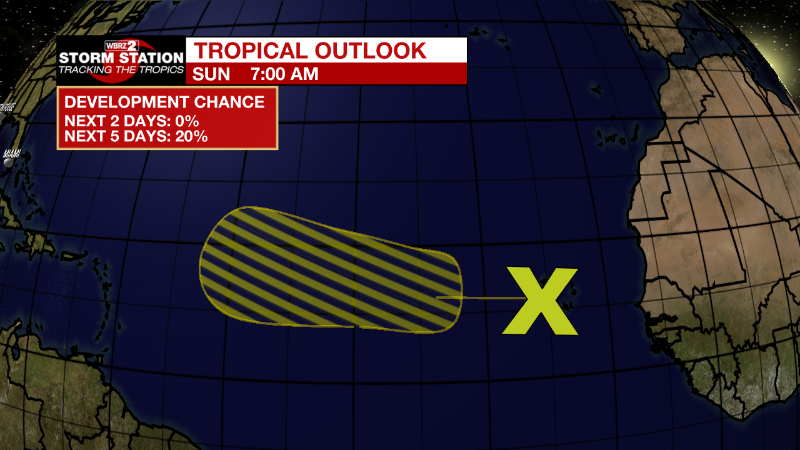
Eastern Tropical Atlantic:
A tropical wave located near the Cabo Verde Islands is producing
disorganized showers and thunderstorms. Environmental conditions
are expected to be marginally conducive for gradual development of
this system while it moves westward to west-northwestward at 15 to
20 mph across the eastern and central tropical Atlantic during the
early to middle part of this week.
* Formation chance through 48 hours...low...near 0 percent.
* Formation chance through 5 days...low...20 percent.
More News
