

Latest Weather Blog
Some will rinse, all will repeat
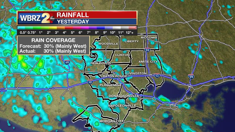
The next two days will bring lower rain coverage before an uptick Thursday and Friday. Temperatures will be close to normal. Monday’s forecast panned out well with highs reaching 92, lows bottoming out in the middle 70s and 30 percent of the 13 Parish, 3 County forecast area receiving rain. Most measurable rain did stay west of the Mississippi River but a few storms did develop east.
THE FORECAST:
Today and Tonight: On Tuesday, mostly sunny skies will promote fast warming into the low 90s by early afternoon. 93 degrees should be met by 2 or 3pm. Light, southeast winds and high humidity will result in feels-like temperatures over 100 degrees for a few hours. An isolated shower or thunderstorm is possible too. Nighttime lows will stop in the mid 70s.
Up Next: Wednesday should run off weather similar to Tuesday before some changes come to end the week. Thursday and Friday will have a less stable atmosphere over Louisiana with the result being scattered afternoon showers and thunderstorms. This more active pattern is expected to carry into the upcoming weekend. More rain and cloud coverage in the afternoon may serve to stop high temperatures just shy of average for the time of year, which is 93 degrees.
Trending News
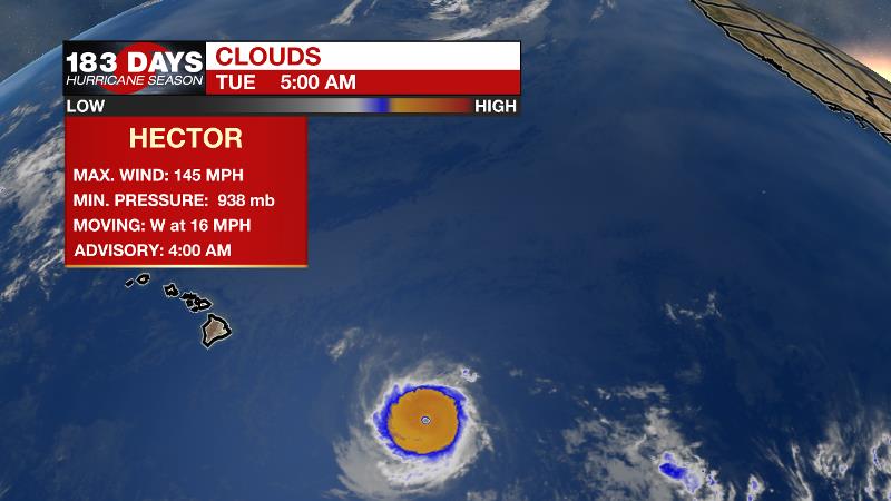
The Tropics: While the Gulf of Mexico and Caribbean Sea remain hot but quiet, a weak disturbance churning in the East Central Atlantic is being monitored by the National Hurricane Center. Not to worry though, this system has a fleeting chance for development at 50 percent and is no threat to the United States. The Eastern Pacific is very active right now with four named storms churning. Hurricane Hector is a dangerous storm that is expected to pass just south of Hawaii’s Big Island causing high surf and wind. Ileana, John, and Kristy will all continue westward into open water. Unusually, Ileana may actually be absorbed by John as the storm strengthens.
THE EXPLANATION:
The overall weather pattern continues to remain rather typical for this time of the year, with continued near-normal afternoon highs and isolated thunderstorms to follow. An upper-level low is expected to weaken over Texas as a broad upper-level ridge will strengthen across the central Gulf Coast. Surface high pressure in the Eastern U.S. will continue to provide onshore flow, which will translate into ample humidity. With this, an isolated shower or thunderstorm will still be able to flare up but rain coverage will only be around 20 percent. By Thursday and into Friday, the surface high and weak upper-ridge will weaken and press east, as a deepening trough develops across the eastern US. This will lead to a series of disturbances riding the northwest to southeast flow aloft, and help increase showers and thunderstorms through late week and even into the weekend.
--Dr. Josh
The WBRZ Weather Team is here for you, on every platform. Your weather updates can be found on News 2, wbrz.com, and the WBRZ WX App. on Apple and Android devices. Follow WBRZ Weather on Facebook and Twitter for even more weather updates while you are on the go.
More News
