

Latest Weather Blog
Friday PM Forecast: short term heat gives way to flood threat next week
The Capital Area will have its hottest temperatures so far this season over the weekend, with feels-like temperatures climbing into the low 100s. Though there are no alerts, take it a little easier in the heat as our bodies are still getting acclimated coming out of the cool season. Relief will arrive early next week, but a stalling weather system will bring the potential for heavy rain and flooding.
Spiking Heat: feels-like temperatures 100-105 degrees this weekend
Stalling Front: rounds of thunderstorms early next week
Flood Risk: 3-6 inches plus over the wet stretch
Tonight & The Weekend: A quiet and warm evening is ahead for the Capital Area. Under mostly clear skies, it will be warm and muggy with overnight lows in the mid 70s. Hot temperatures will hold their ground through the weekend. With humidity slowly creeping up as well, feels-like temperatures will go well over 100 degrees, climbing as high as 105 degrees. As afternoons heat up the landscape, typical coastal breezes will develop and trigger isolated showers and thunderstorms. Know that there will be plenty of dry time each day; just have a nearby lightning shelter in case of one of those passing storms. Any activity that pops will fizzle after sunset.
.png)
Trending News
Up Next: As the weekend comes to a close, the weather pattern will shift as a weak cold front moves into the Southeast. Ahead of this feature, deep tropical moisture will pool in the atmosphere and result in a round of stormy weather early next week. The incoming cold front will lose its forward push on Monday, parking itself directly over northern Louisiana. This stalled boundary will act as a track for repeated rounds of heavy thunderstorms Monday through at least Wednesday. Because our soils have already absorbed over a foot of rain in the past month, a flash flooding situation could develop a little more easily than usual.
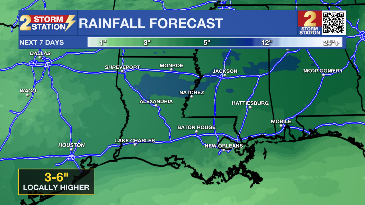
Monday afternoon through Wednesday, occasional downpours capable of dumping 2 to 3 inches of rain per hour will be possible. Many spots will pick up 3 to 6 inches of water by Wednesday night, and a few areas could see total rainfall amounts over 10 inches. Street flooding will be a concern for all commutes through the middle of the week. Keep an eye out for standing water and never drive through flooded roadways. The National Weather Service (NWS) may issue a Flood Watch to account for this threat. Temperatures will not climb above 90 degrees due to the clouds and rain.
By Thursday, the front will dissipate and showers and thunderstorms will get back to a more typical pattern of popping up due to daytime warming. Also, highs will return to the 90s.
Get the latest 7-day forecast and real-time weather updates HERE.
Watch live news HERE.
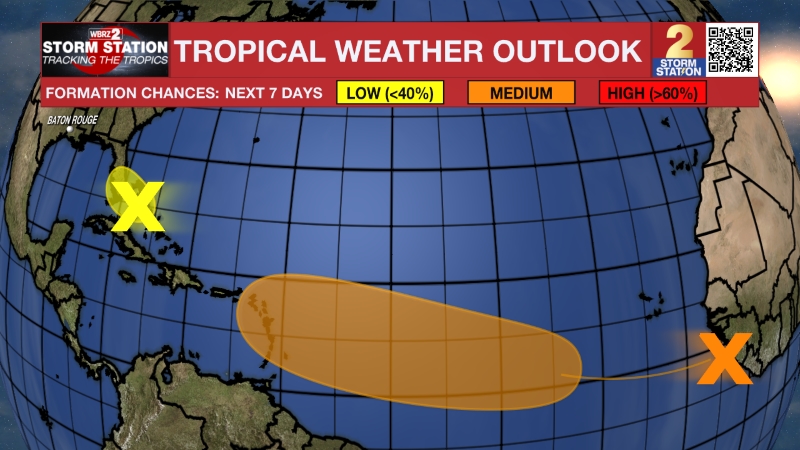
The Tropics: A broad area of low pressure over the Bay of Campeche is producing disorganized shower and thunderstorm activity, but it faces an uphill battle for development. Environmental conditions remain only marginally favorable for the system as it tracks toward eastern Mexico, where it will likely move inland late Saturday or Sunday. Looking ahead into next week, the system could re-emerge over the northwestern Gulf on Tuesday or Wednesday and interact with a frontal boundary. However, atmospheric conditions are expected to remain unfavorable for significant organization in that area as well, keeping the overall chance for tropical cyclone formation at a low 20 percent.
– Josh
The Storm Station is here for you, on every platform. Your weather updates can be found on News 2, wbrz.com, and the WBRZ WX App on your Apple or Android device. Follow WBRZ Weather on Facebook and X for even more weather updates while you are on the go.
More News
