

Latest Weather Blog
Friday PM Forecast: front brings refreshing start to weekend, but also wildfire danger
A dry cold front is sweeping through tonight, bringing a welcome spring reset with temperatures finally returning to normal. However, this refreshing change will come with a catch. Gusty winds and low humidity will make a wildfire risk through the start of the weekend.
Saturday: cooler and drier, critical fire weather
Sunday: first (small) chance of rain again
Next Week: showers possible each day
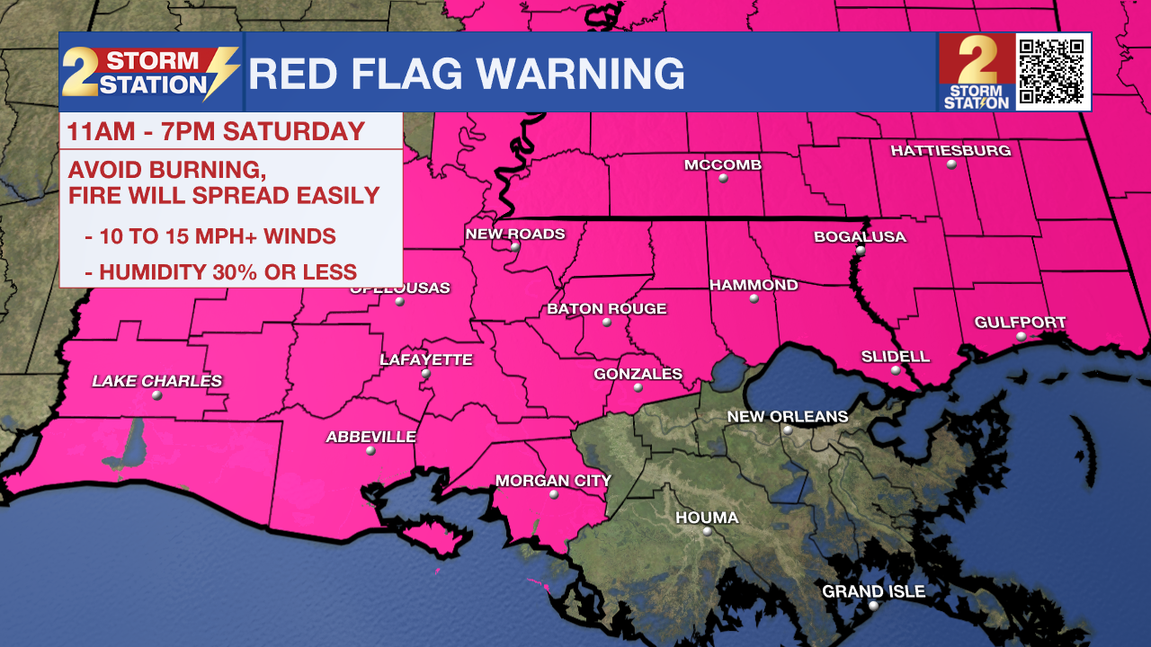
Red Flag Warning: The National Weather Service has issued a Red Flag Warning for all of southern Mississippi and much of southeast Louisiana from 11 AM to 7 PM Saturday. This warning indicates that critical fire weather conditions are expected due to a combination of dry air and gusty winds.
With humidity levels dropping as low as 20% and northeast winds sustained at 15 to 20 mph—with gusts reaching up to 30 mph—any spark that catches could lead to a wildfire that spreads rapidly. It is advisable to postpone all outdoor burning, including trash or brush, and to exercise extreme caution with any equipment that could create a spark near dry vegetation.
Trending News

Tonight & Tomorrow: Tonight, you will notice the breeze picking up and changing to a northwesterly direction as a cold front passes. The cold front will come by "dry," meaning that we will get a change without any rain. Lows will bottom out in the mid-50s. On Saturday, expect a sunny and beautiful, but breezy day. Highs will top out in the mid-70s.
The front will leave behind a "tight pressure gradient." To put that simply, imagine squeezing a tube of toothpaste—the harder you squeeze, the faster the paste comes out. In the atmosphere, the difference between high pressure over Texas and low pressure in the Gulf "squeezes" the air, creating north winds of 15-20 mph with gusts up to 30 mph. Because the humidity will be very low, it is a good idea to avoid outdoor burning or tossing cigarettes, as fires will start and spread easily in these conditions.
Up Next: The dry weather will not last long. By Sunday, winds will shift to the south, pumping moisture back into the region. While the fire danger will slowly ease, the humidity will make it feel muggy again. As we head into next week, the weather will transition into a summer-like pattern. Expect highs to climb back into the mid-80s with "pop-up" showers and thunderstorms becoming a daily occurrence during peak afternoon warming. As of now, no full-day washouts are expected, and most neighborhoods will collect around an inch of rain through next week.
Get the latest 7-day forecast and real-time weather updates HERE.
Watch live news HERE.
– Josh
The Storm Station is here for you, on every platform. Your weather updates can be found on News 2, wbrz.com, and the WBRZ WX App on your Apple or Android device. Follow WBRZ Weather on Facebook and X for even more weather updates while you are on the go.
More News
