

Latest Weather Blog
Friday AM Forecast: Cold front delivers refreshing feel, and a fire weather risk
The quiet weather pattern that we have been experiencing is about to shift. A cold front will deliver a refreshing weekend feel, and even a risk for fires to spread quickly. Heading into next week, rain chances will be on the rise.
Dense Fog Advisory: The National Weather Service has issued a DENSE FOG ADVISORY for portions of southeast Louisiana and south Mississippi, in effect until 9 AM Friday. Visibility may decrease to one-quarter mile or less. Be sure to exercise caution on the roads, especially near ongoing marsh fires, where super fog could form and reduce visibility to near zero.
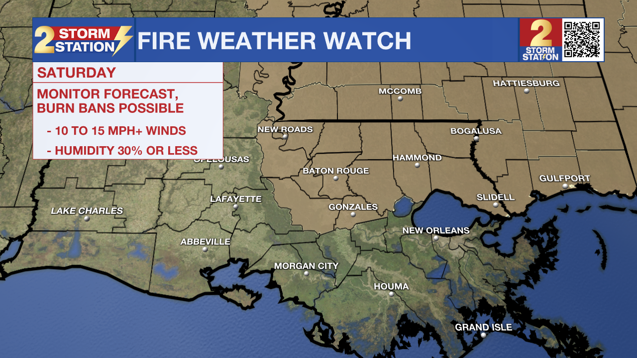
Fire Weather Watch: The National Weather Service has also issued a FIRE WEATHER WATCH for portions of southeast Louisiana and south Mississippi, in effect from Saturday morning through Saturday evening. A much drier air mass, gusty northwesterly winds of 10 to 15 mph, and relative humidity values as low as 20 to 25 percent will combine to create conditions favorable for the development and rapid spread of wildfires. Use extreme caution with any ignition sources and be aware of any burn bans in your area.

Today & Tonight: Once we shake off any morning fog, the sun is set to dominate for another afternoon of unseasonable warmth. Expect highs to push into the upper 80s—creeping remarkably close to record territory. This looks to be our final day with this type of warmth, as a dry cold front is scheduled to sweep through Friday night. While it won't offer much in the way of rain, it will successfully reset our thermometer to more typical spring levels for the weekend. Lows tonight will reach into the mid-50s.
Trending News
Up Next: Post-cold front, a much drier air mass will push in from the north on Saturday, dropping humidity levels and kicking up some breezy winds. This combination will lead to fire weather concerns, so please be extra careful with any outdoor sparks or flames (check the Fire Weather Watch section for the full breakdown). Outside of the wind, it’s shaping up to be a beautiful, sunny day with very comfortable highs in the mid-70s.
Expect a shift on Sunday as warmer, moister air begins to creep back into the region. As that moisture builds, we can't rule out a stray, light shower, but most of the afternoon will remain partly sunny with temperatures climbing into the upper 70s and low 80s.
The upcoming workweek introduces a more unsettled pattern, with isolated to scattered showers and thunderstorms possible on a daily basis. Since we aren't seeing any organized storm systems on the horizon, don't worry about any total washouts—these will be "passing" showers that move through quickly. It's highly unlikely any one spot sees rain every single day, and since totals will stay light, any moisture we do get will be a welcome sight for our thirsty lawns. Afternoon highs will settle back above the seasonal norm in the low 80s, with mild mornings in the low 60s.
Get the latest 7-day forecast and real-time weather updates HERE.
Watch live news HERE.
– Balin
The Storm Station is here for you, on every platform. Your weather updates can be found on News 2, wbrz.com, and the WBRZ WX App on your Apple or Android device. Follow WBRZ Weather on Facebook and X for even more weather updates while you are on the go.
More News
