

Latest Weather Blog
A quiet beginning to the new week
The nice Easter Weekend weather will carry over into the early part of this week. Rain and thunderstorms will not return to the area until late Wednesday.
THE FORECAST:
Today and Tonight: Surface high pressure continues its reign over the area, but it is beginning to move east and is approaching Florida. So for today, highs will bump up to near 82 degrees and sunshine will continue but a few thin clouds may appear through the day. Light, southeast winds and increasing clouds overnight will result in lows near 58 degrees.
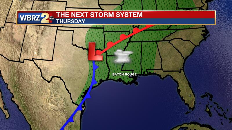
Up Next: Skies will be partly to mostly cloudy on Tuesday. This will take shape ahead of a low pressure system that will move in from the west late Wednesday, bringing a return of showers and thunderstorms through the latter half of the workweek. Storm activity will peak Thursday afternoon and extend into Friday. The low will push east into southern Alabama and Georgia on Friday evening, allowing clouds to break up through the night. High pressure follows in behind the low pressure on Saturday, bringing back sunny skies and above average temperatures for the upcoming weekend. Highs will stay confined in the low-to-mid 80s through the week, as lows hover in the low 60s.
Trending News
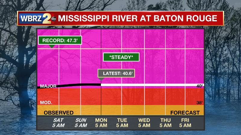
The Mississippi River: At Baton Rouge, major flood stage continues with a level of 40.6’ as of Monday morning. Peaking at 44.1’ on March 19, the river set its 7th highest recorded crest at Baton Rouge. In addition, at 107 days this is now the 3rd longest period above flood stage. River flooding and drainage north of the area will keep the river steady over the next several days. The high water is primarily an issue for river traffic and river islands, although some inundation will continue unprotected low-lying areas. The city of Baton Rouge and the main LSU campus are protected by levees up to 47 feet. Some soggy areas and seepage may be noted due to the long duration of high water placing pressure on the levees. As some of the Mississippi River diverts into the Atchafalaya River, gauges at Krotz Springs and Morgan City will stay high as well. This creates backwater flooding in parts of Assumption Parish in areas such as Stephensville and around Lake Palourde. Like Big Muddy, this is expected to be a prolonged event but is not uncommon for the time of year. Read more HERE.
THE EXPLANATION:
The local weather will remain under the influence of a broad ridge of high pressure, which will keep the region dry and allow gradually warming temperatures. Southeast winds will become more established overnight allowing low temperatures to stay up a few degrees compared to the last few mornings. The axis of the ridge will bounce east on Tuesday and therefore mid to upper level moisture will pass over the area resulting in some cirrus cloud development. Transitional weather will continue on Wednesday with similar skies and temperatures. Forecast models are in agreement on bringing a surface low pressure system an attendant cold front into eastern Texas in Wednesday night. Showers and thunderstorms will press in from the west, weakening, but affecting areas west of the Mississippi River by daybreak. As the cold front moves across the area on Thursday, conditions will be more favorable for better organized showers and thunderstorms to develop. While there is confidence in the timing of best rain chances coming on Thursday afternoon, there is not much confidence on rain amounts and thunderstorm strength. Forecast models are showing slightly higher amounts on the Louisiana coast and in southwest Mississippi which could result in a miss for the I-10/12 corridor. If the heaviest action does indeed happen along the coast, severe weather is unlikely farther north. If the activity is a bit more scattered south, there will be enough energy available for some stronger storms around the Baton Rouge area. Either way, at this time, the threat does not look as high or widespread as the last four events. An upper level trough will linger over the area on Friday allowing enough instability for some showers and thunderstorms to develop due to daytime warming. A clear, mild weekend will follow, but it will not be as cool behind that front as this past one.
--Josh
The WBRZ Weather Team is here for you, on every platform. Your weather updates can be found on News 2, wbrz.com, and the WBRZ WX App. on Apple and Android devices. Follow WBRZ Weather on Facebook and Twitter for even more weather updates while you are on the go.
More News
