

Latest Weather Blog
Wednesday AM Forecast: Rinse and repeat pattern continues
Showers are expected each afternoon, but not everyone will see rain.
THE FORECAST
Today & Tonight: The rinse and repeat pattern continues. This morning we are waking up to temperatures in the low-70s and a thick layer of cloud cover. There are no heat advisories expected today as daytime highs will top out in the mid-90s again, but those feels like temperatures will top out at about 103°. Just how hot you get and how long you stay hot will all be dependent on when and where showers develop. Areas south of I-10 are more likely to see isolated PM showers. There is not a severe weather outlook for today, but one or two storms will have the capability to become strong. Overnight the pattern will repeat.
Up Next: Heat has been on repeat day after day, but now some changes are setting into the forecast. Thursday you will wake up to partly cloudy skies and temperatures in the low-70s. The humidity is still there but the heat is backing off. By the afternoon, you will be sitting in the mid-90s. A few isolated showers will be possible with a few stronger storms in the mix. Our typical summertime pattern is beginning to settle in. Through the end of the week, we will be starting each day warm and humid with temperatures in the upper-70s low-80s. Throughout the day, temperatures will climb into the low-to-mid 90s and feels like temperatures will be triple digit heat. But the string of excessive heat warnings and heat advisories will not continue. Rain will be around the area everyday. Click here to see the 7-day forecast.
The Storm Station has you covered with hour-by-hour weather tracking is available for your location on the WBRZ WX App on your Apple or Android device. Follow WBRZ Weather on Facebook and Twitter for even more weather updates and unique weather insight from the whole team!
In the Tropics:
Trending News
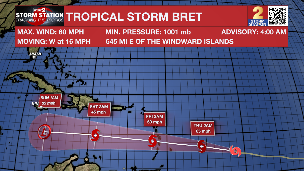
Tropical Storm Bret has strengthened over the central Atlantic Ocean with maximum sustained winds up to 60mph and some additional strengthening expected. Still over 1,000 miles east of the Windward Islands, Bret will continue west at about 18mph before moving over the Lesser Antilles Thursday night. The system is expected to degenerate into an open tropical wave over the weekend in the Caribbean Sea due to harsh wind shear.
In the eastern Atlantic, showers and thunderstorms have diminished during the past several hours in association with a tropical wave located several hundred miles southwest of the Cabo Verde Islands. However, environmental conditions appear conducive for further development of this system, and there is an eighty percent chance that a tropical depression will form during the next couple of days while the system moves westward at 10 to 15mph across the eastern and central tropical Atlantic.
More News
