

Latest Weather Blog
Two rounds of showers locally, major storm may snarl return travel
Your Black Friday may involve an umbrella. Two more periods of rain are in the forecast before cooler air and an extended dry spell arrive.
THE FORECAST:
Today and Tonight: Shoppers should enjoy cool, dry weather through Friday morning but late in the day, a more potent storm system will track through southeast Louisiana with widespread rain and isolated thunderstorms. Up to a half inch of precipitation is possible, most of which will occur during the afternoon and evening hours. Highs will make it into the middle 60s with overnight lows falling into the low 50s after showers end.
Up Next: After a break on Saturday, another fast moving storm system returns showers to the forecast on Sunday followed by much cooler temperatures. Cool, quiet weather is then expected through Wednesday.

Trending News
It is worth noting that a significant winter storm will develop and spread across the Midwest through the weekend. From the Rocky Mountains eastward to the Mississippi, heavy snow and ice will be possible. Holiday travelers coming through major cities like Chicago, Denver, Des Moines, Kansas City and Lincoln may expect delays.
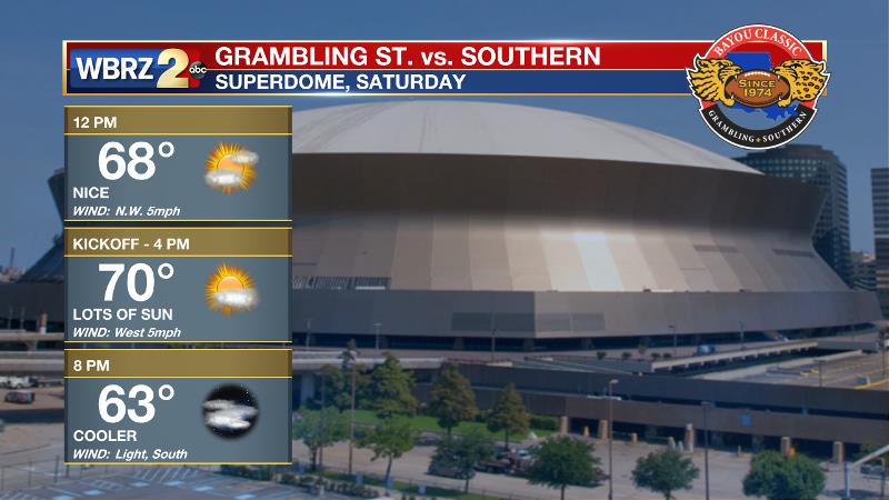
Football Forecasts: Both the Bayou Classic and the season finale for LSU will enjoy quiet weather on Saturday. In New Orleans, a partly sunny and seasonable day is expected with pre-game festivities enjoying temperatures in the upper 60s. For College Station, the Tigers and Aggies will kickoff to a temperature in the low 60s beneath partly cloudy skies.
The Tropics: With just under two weeks left in the official hurricane season, all is quiet. No development is expected in the Gulf of Mexico, Caribbean Sea or Atlantic Ocean.
THE EXPLANATION:
The next in a parade of shortwave troughs and vorticity maxima will approach the area late Friday. A surface low will develop in the baroclinic region east of Brownsville, Texas and eject northeastward through the central Gulf of Mexico. The surface low will likely move along the Louisiana Coast toward the Florida Panhandle, therefore keeping most instability south of the state. As a result, severe weather chances will be minimal as a batch of rain and embedded thunderstorms moves through. Rainfall of about a half inch is expected, mainly during the afternoon and evening hours. Another lull is expected to begin the weekend. Then finally, the strongest in this batch of shortwaves will move across the center of the country on Sunday. With a more pronounced surface low expected to develop and move across Missouri, the trailing cold front will move through the area sometime late Sunday. Normally, this would pose a threat of severe weather somewhere in the lower Mississippi River Valley, but current indications are that moisture availability could be an issue. Cold air advection will continue behind that boundary on Monday, with highs struggling to reach the mid 50s. Monday and Tuesday nights look to be the coldest, with lows dropping into the 30s both nights. Some forecast models point to freezing temperatures in typical cool spots north of I-12 both nights, so we will need to monitor that potential through the weekend. Dry conditions will last through at least Wednesday with plenty of afternoon sun.
--Dr. Josh
The WBRZ Weather Team is here for you, on every platform. Your weather updates can be found on News 2, wbrz.com, and the WBRZ WX App. on Apple and Android devices. Follow WBRZ Weather on Facebook and Twitter for even more weather updates while you are on the go.
More News
