

Latest Weather Blog
Tuesday PM Forecast: cold front to bring late week wintry weather potential
After a cold front moves through the area early Thursday morning, much colder air will spill into the region. On Friday, freezing temperatures will arrive just as another disturbance moves across the Gulf of Mexico. This will send some precipitation inland and creating a potential for ice accumulation.
Watch WBRZ Plus live stream here.
Next 24 Hours: Thanks to south winds of 5-10mph, a much warmer night is ahead and low temperatures will basin in the low 50s. Beneath partly sunny skies, high temperatures will peak in the mid 70s on Wednesday afternoon. Clouds will start to increase late ahead of a strong cold front. While an isolated shower or thunderstorm is possible in the afternoon and evening, the bulk of the rain will wait until a line arrives during the overnight hours. Like other recent events, the threat for any severe thunderstorms is low, but a few strong wind gusts are possible.
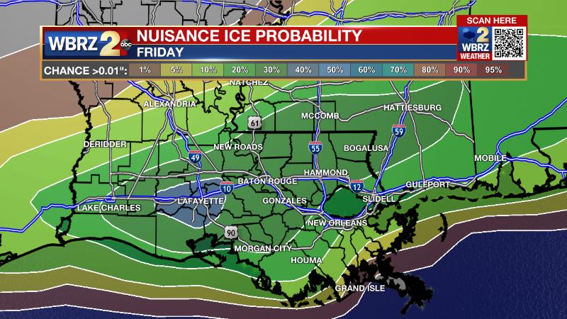
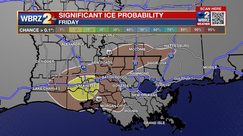
Up Next: Rain will linger, mainly into early Thursday, with clouds likely through the daylight hours. At the same time, much colder air will dive into the area with pre-dawn highs in the mid 50s falling into the low 40s by late afternoon. A fast-moving disturbance will move into the region Thursday night into Friday, returning precipitation to areas along and south of the state line. While rain is expected to fall, below freezing temperatures on Friday morning will open a window of time from 12am – 10am for light ice accumulations. For the entire WBRZ Weather Forecast Area, there is a 30 percent chance of nuisance ice accumulations, over 0.01 inches, which could create slick roads. Isolated areas could receive up to 0.1 inches, which would add a threat for tree and powerline damage, but those chances are less than 5 percent.
Trending News
Precipitation will end by midday Friday and temperatures will briefly climb above freezing before crashing into a hard freeze in the mid 20s on Saturday morning. Continue to check with the Storm Station for updates. CLICK HERE for your detailed 7-Day Forecast.
The Explanation: sustained onshore winds will cause dew point temperatures to increase into the 50s and therefore a substantially warmer night into Wednesday morning. The rising moisture will prime the atmosphere ahead of the next cold front moving into the region on Wednesday evening. A strong, upper level shortwave trough of low pressure will move out of the Great Lakes region and dig southeast sending a cold front into the area. Limited instability will keep most of Wednesday dry and warm with high temperatures surging into the 70s. As the cold front arrives, the lift created will cause a line of showers and thunderstorms to develop. Given the previously mentioned weak instability, and modest upper level winds, the chance for severe weather again looks low, but is non-zero. The front will quickly push through the area, ending up in the Gulf of Mexico by Thursday morning. Periods of rain are expected to linger behind the front on Thursday morning but should gradually diminish from west to east. Clouds will hang on through the afternoon. All of this will lead to another wild temperature ride with highs in the 50s occurring just after midnight on Thursday followed by stiff northerly winds and sharply colder air in the low 40s by late afternoon. The forecast grows more challenging into Friday. The cold front will slow down in the northern Gulf of Mexico. Late Thursday, an upper level disturbance is expected to move from west to east across the region enhancing lift around the front. While most of the atmosphere will be too warm to support anything but liquid, cold and possibly below freezing air will be in place at the surface. As a result, away from the immediate coastline, a swath of freezing rain is possible Thursday night into Friday, possibly accumulating up to one tenth of an inch. The inland extent of precipitation will be limited to areas south of the Mississippi border and could even be limited to areas south of I-12. Any ice accumulations could result in slick roads, especially on elevated surfaces and spotty tree and powerline damage. Thermometers will warm above freezing later Friday as drier air moves in ending precipitation. However, ongoing clouds will keep it rather cold with highs likely remaining in the upper 30s. With such a low starting point and some clearing anticipated overnight, low temperatures will plummet into the mid to upper 20s on Saturday morning and some locations could experience a hard freeze. As a surface high pressure system builds into the region over the weekend, skies will continue to clear out and high temperatures will moderate back into the 40s and 50s—warmer than Friday—but still well below average. Below freezing temperatures are expected on Sunday and Monday morning as well.
--Josh
The WBRZ Weather Team is here for you, on every platform. Your weather updates can be found on News 2, wbrz.com, and the WBRZ WX App on your Apple or Android device. Follow WBRZ Weather on Facebook and Twitter for even more weather updates while you are on the go.
More News
