

Latest Weather Blog
Tropical Storm Bertha approaching the coast; Extreme Heat Warning in effect
Tropical Storm Bertha continues to meander along the Northern Gulf Coast. The system has already reached its peak intensity, as a combination of wind shear, dry air, and land interaction will continue to hamper Bertha. This is very evident with the latest satellite and radar scans, showing the heaviest rain and storms well south of the center of circulation. This exposes Bertha's center and makes the storm even more vulnerable to the hostile atmospheric conditions.
Landfall is likely to occur in far southeastern Louisiana sometime on Wednesday. The storm center will continue west through coastal Louisiana through Wednesday night and early Thursday, continuing to weaken in the process. Bertha will eventually dissipate and become post-tropical over Texas by the end of the week. A Tropical Storm Warning remains in effect along the immediate coast from the Okaloosa/Walton County line in Florida to Morgan City, Louisiana. Slidell, New Orleans, and Lake Pontchartrain are also included. Meanwhile, a Tropical Storm Watch remains in effect for Lake Maurepas, as well as coastal regions west of Morgan City to Sargent, Texas.
Inland impacts will be limited with this system. Count on plenty of dry windows as Bertha glides past, with most of Wednesday turning out dry for the Capital Area. As the system pulls west on Thursday, rain chances will increase once again as tropical rainbands move through. The heaviest rain will remain over open water. Areas along the immediate coast could pick up 1-2" of rain, but even those totals will be somewhat spotty. Most locations will see less than an inch, with a few spots missing rain altogether.
Coastal storm surge and flooding remain a threat. As tide and surge stack up, usually dry shoreline zones could sit under 2 to 4 feet of water from the Mouth of the Mississippi River out to the Mississippi/Alabama state line. Nearby bodies of water, such as Lake Pontchartrain and surrounding stretches of the Louisiana coast, are looking at potential 1-to-3-foot rises. These impacts will start being felt on Wednesday and continue on Thursday. At the same time, swells pushing west are setting up dangerous surf and life-threatening rip currents along much of the northern Gulf through the next couple of days.
Winds won't be a major issue, though coastal communities could see occasional gusts hovering right around tropical storm force (39 mph). Inland areas will mostly just deal with light 10–20 mph breezes, with some stronger gusts up to 30 mph.

An EXTREME HEAT WARNING is set to take effect from until 8 p.m. Wednesday for portions of southeast Louisiana and southern Mississippi. Dangerously hot conditions are possible with heat index values expected to reach up to 113°. That kind of heat and high humidity can cause heat illnesses. Drink plenty of fluids, stay in an air-conditioned room, and stay out of the sun when possible. Those who do go outside should wear lightweight and loose-fitting clothing and try to limit strenuous activities to early morning or evening.
Trending News
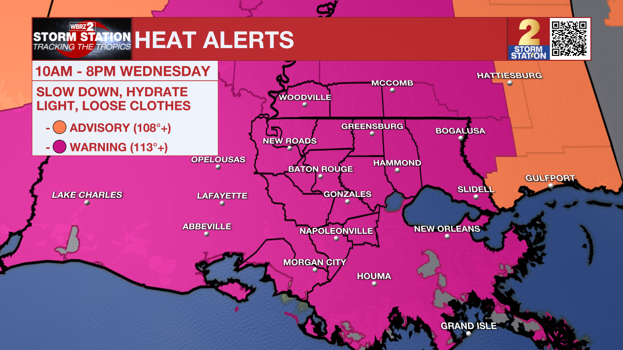
Today & Tonight: Even with Bertha tracking nearer to the state on Wednesday, rain coverage will actually turn out lower than what was seen Tuesday thanks to the storm's "lopsided" nature. Even so, an isolated shower or storm cannot be ruled out. However, extreme heat will be the primary weather impact. Heat indices could surge as high as 113° as afternoon highs reach the upper 90s alongside muggy, tropical moisture. Consequently, an EXTREME HEAT WARNING covers the entire Baton Rouge metropolitan area. Expect breezy conditions throughout the day, with wind gusts up to 30 mph as Bertha makes its nearest approach. These conditions will linger through tonight, accompanied by ongoing chances for an isolated shower or storm and overnight lows dipping into the upper 70s.

Up Next: Periodic tropical downpours will continue through Thursday. Outside of these showers, intense heat and humidity will dominate. As the tropical system pulls away late in the week and into the weekend, the summer heat will continue to bake the Capital Area.

The Tropics: Elsewhere in the basin, all is quiet. No additional development is expected in the Gulf, Caribbean or Atlantic.
Get the latest 7-day forecast and real-time weather updates HERE.
Watch live news HERE.
— The Storm Station Meteorologists
The Storm Station is here for you, on every platform. Your weather updates can be found on News 2, wbrz.com, and the WBRZ WX App on your Apple or Android device. Follow WBRZ Weather on Facebook and X for even more weather updates while you are on the go.
More News

