

Latest Weather Blog
Tracking thunderstorms Tuesday afternoon and evening
Click here to watch a live update on potential severe weather
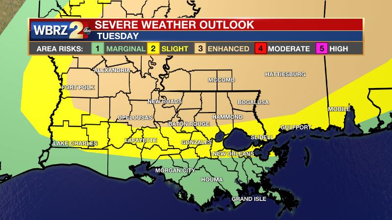
Stay weather aware! The entire WBRZ viewing area is once again under a severe weather risk for Tuesday afternoon and evening. Yes, the message begins to sound repetitive this time of year as frontal systems can bring a possibility for severe weather every few days. No less, some of the ingredients will be available so that we need to pay attention.
THE FORECAST
Tonight: Clouds will gradually thicken overnight. With a lot of humidity lying around, temperatures will only settle into the mid 70s overnight with continued south winds of 5-10mph.
Tuesday: There is a 3/5 "enhanced risk" for severe weather along and north of I-10 with a decreasing risk south of the highways. Tuesday is expected to begin with mostly cloudy to partly sunny skies. Any sunshine will help to run thermometers into the mid 80s and energize the atmosphere. A band of storms will move through the area from northwest to southeast during the afternoon and evening hours. This may cause some delays for the drive home from work and school. Storms will be capable of producing damaging winds, large hail, downpours, or even a tornado. One question mark will be the end time of precipitation. If the front and associated line slow down, there could be a period of heavy rain leading to some localized flooding. However, our current thinking is that the batch of rain and thunderstorms will be progressive, ending from north to south overnight into Wednesday.
Trending News
Up Next: Wednesday morning will have a few leftover showers and thunderstorms. Then the clearing will begin. Some drier air will move in and Wednesday afternoon will be mostly sunny with temperatures in the low 80s and overnight lows in the low 60s. The drier air will allow for temperatures to drop into the upper 50s on Friday and Saturday morning. Mostly sunny and dry conditions will continue through the weekend. Click here to see the 7-day forecast.
Reminder: With the threat for impactful weather—severe thunderstorms—please have access to alerts through Saturday. You can download or activate the WBRZ WX App on your Apple or Android device or turn on a NOAA Weather Radio for bulletins such as watches and urgent warnings. Of course, WBRZ, WBRZ+, and the Cable Weather Channel will have updates as active weather dictates. For more information on severe weather safety and specific hazards, CLICK HERE.
More News
