

Latest Weather Blog
Thursday shaping up to be rainier than Wednesday
A FLASH FLOOD WATCH is posted for the entire viewing area, through Thursday evening. Additional rainfall of 1 to 3 inches with locally higher amounts will be possible. The most likely areas for heavy rainfall will be along and south of the I-10/12 corridor in Southeast Louisiana including portions of metro Baton Rouge and metro New Orleans. These heavier rainfall amounts could cause localized flash flooding issues. High rainfall rates could overwhelm drainage capacity. Ponding of water in low-lying and poorly drained areas will be possible, and flash flooding could occur where the heaviest rain occurs.
THE FORECAST
Today & Tonight: There will be some heavy downpours in the area this morning along a line of showers and storms. The line will make its way from west to east weakening as it goes. Areas further west will be most likely to see the heavy downpours this morning. For the rest of the day showers and storms will spark up along a moisture stream moving southeast to northwest. Heavy downpours will be possible again with afternoon rain and that’s why the Flash Flood Watch has been extended through this evening. Temperatures will be near 80 degrees this afternoon. Overnight we will get some dry time and temperatures will again be near 70 degrees.
?? East #BatonRouge, Ascension:
— Josh Eachus (@DrJoshWX) May 19, 2021
This ongoing, stiff southeast breeze is not just a problem for coastal areas. Those winds are very likely causing water to drain more slowly from Bayou Manchac. #LaWX https://t.co/ZY3tRUSb2B
Up Next: Strong winds out of the southeast will eventually turn eastward on Friday. Showers will be bubbling up once again in the late morning and early afternoon, but the easterly winds will push most of the action off to the west. Areas furthest west will be most likely to see showers. By the end of the day Friday, we will start to dry out. Heading into the weekend high pressure will move in and keep rain out of the forecast for a while. Temperatures will climb into the low 90s with plenty of sun early next week. Click here to see the 7-day forecast.
RIVER STAGES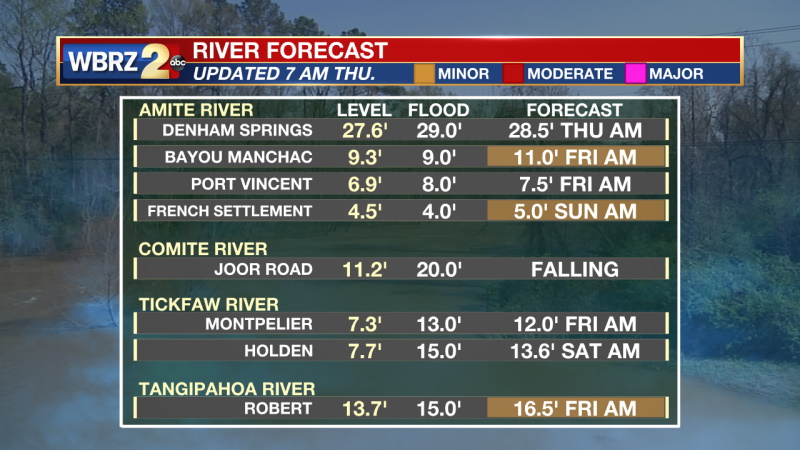
Trending News
In the Tropics:
June 1st and the start of Hurricane Season are right around the corner. We are looking at the first disturbance of the season. It is located out in the Atlantic and will not be a concern for the Gulf of Mexico.
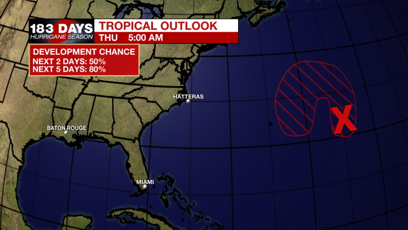
A non-tropical low pressure system has developed within a broad area of cloudiness and thunderstorms about 600 miles east-southeast of Bermuda. The low is expected to develop gale-force winds later today while it moves generally northward. The low is forecast to move westward and southwestward over warmer waters on Friday, and will likely become a short-lived subtropical cyclone near and to the northeast of Bermuda on Friday. The system is expected to move toward the north and northeast into a more hostile environment by late Sunday into Monday. For more information on this developing low pressure area, please see High Seas forecasts issued by the NOAA Ocean Prediction Center and forecast products issued by the Bermuda Weather Service.
* Formation chance through 48 hours...medium...50 percent.
* Formation chance through 5 days...high...80 percent.
Get right now weather conditions for your location on the WBRZ WX App on your Apple or Android device. Follow WBRZ Weather on Facebook and Twitter for even more weather updates and unique weather insight from the whole team!
More News
