

Latest Weather Blog
Thursday PM Forecast: warm, drier through Saturday
Generally calm weather will lead us into the weekend. Thermometers will remain warm by late October standards.
Next 24 Hours: A weakening front will move into the area tonight. It is not expected to make a major impact. Therefore, expect mostly clear skies with some patchy fog developing near dawn. Low temperatures will be in the mid 60s. Friday will be a quiet day with slightly lower humidity and mostly sunny skies. High temperatures will be in the mid 80s.
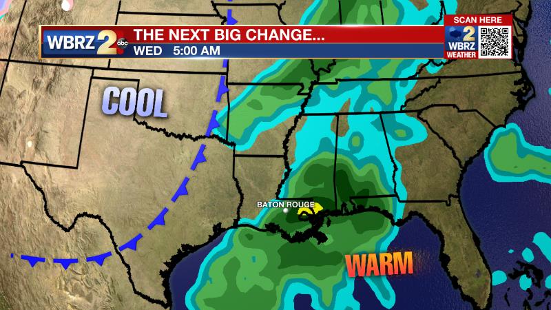
Up Next: Into the weekend, humidity will be in check but temperatures are expected to remain above their seasonal averages of highs near 79 and lows near 56. In other words, it will not be as cool behind this front as the one last weekend. However, rain chances will stay very low making for largely cooperative outdoor weather through Saturday. Continue to check in with the forecast for Sunday and Monday if you have outdoor plans, as it is unclear whether or not a fast moving disturbance will send a round of showers and thunderstorms through the area. Beyond that, Tuesday is expected to be dry followed by a more substantial front on Wednesday. While it is early, this system is worthy of some attention for stronger thunderstorms until details become clearer. Behind it, cooler temperatures are anticipated for the end of next week. CLICK HERE for your full 7-Day Forecast.
The Tropics: For the North Atlantic, Caribbean Sea and Gulf of Mexico, tropical development is not expected over the next five days. As we move into late October, it is increasingly rare for tropical systems to strike Louisiana. In fact, with records dating back to the 1860s, only four storms have made landfall past October 20. For the latest tropical forecasts, advisories and information, visit the WBRZ Hurricane Center as we navigate all 183 Days of Hurricane Season.
The Explanation: A weak upper level trough will lift northeastward, further away from the region on Friday morning with a dissipating front trying to enter the Gulf of Mexico. As a result, more stable and a deeper drier air mass will take hold into Friday. Temperatures will not cool much behind the weak front and should remain above average. Still, through Saturday, more pleasant conditions are expected with lower humidity and limited cloud development. With regard to precipitation, uncertainty increases Sunday through Tuesday. The ECMWF model suggests a fast moving upper level trough will cut across the area early Monday with a round of showers and thunderstorms. The GFS model is not finding this feature and would result in continued dry, warm weather.
Trending News
Then on Wednesday, both models come back into agreement in bringing a deeper upper level trough into the region. This system will be accompanied be a more demonstrable cold front. At about a week out, there are some timing clarifications needed but the main idea is that falling temperatures can be expected around midweek. Additionally, the track of the parent, upper level storm system requires at least some monitoring for stronger thunderstorms.
--Josh
The WBRZ Weather Team is here for you, on every platform. Your weather updates can be found on News 2, wbrz.com, and the WBRZ WX App on your Apple or Android device. Follow WBRZ Weather on Facebook and Twitter for even more weather updates while you are on the go.
More News
