

Latest Weather Blog
Thursday AM Forecast: An abundance of moisture, and more rain expected today
THE FORECAST
Today & Tonight: Waking up to plenty of moisture in our area. Coastal showers are already bubbling up and will be moving inland earlier today. Most people will see a shower today. Expect to start seeing some rain on your lunch break and it will stick around during the afternoon hours. These showers and storms will be slow moving, and could produce a heavy downpour, gusty winds, and frequent lightning. Across the area there could be some localized street or poor drainage flooding. Temperatures will top out in the low 90s. As we head into the overnight hours clouds and moisture will be sticking around and temperatures will fall into the low-70s.
A marginal risk for excessive rainfall is in effect for our area today, and will continue until Saturday.
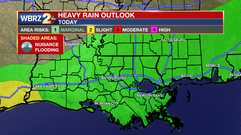
Up Next: Friday the pattern repeats. The abundance of moisture will help fuel some showers across the area. These showers will be slow moving, and have the ability to drop 1-2” of rain per hour. This could potentially cause some street and poor drainage flooding issues. Heavy cloud cover will hold daytime high temperatures in the low-90s across the area. Once the showers begin to fizzle out across the area we will be waking up to temperatures in the low-70s with clouds. Saturday the marginal risk for excessive rainfall in still in effect in our area. These showers will be slow moving and will have plenty of opportunity to drop 1-3” of rain in short periods of time. Seasonable temperatures and afternoon showers will stick around into the 4th of July weekend. Click here to see the 7-day forecast.
Hour-by-hour weather tracking is available for your location on the WBRZ WX App on your Apple or Android device. Follow WBRZ Weather on Facebook and Twitter for even more weather updates and unique weather insight from the whole team!
Trending News
In the Tropics:
Potential Tropical Cyclone 2 is bringing the threat of heavy rain and tropical storm force winds to countries in the Caribbean. This storm is not a threat to the local area. CLICK HERE to see the latest forecast cone for PTC 2.
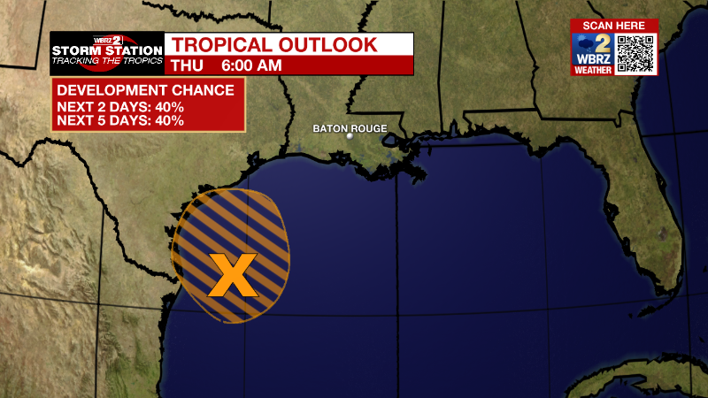
There is a tropical disturbance in the Gulf of Mexico that is promoting extra rainfall this week. It may become a short-lived tropical depression. It is approaching the southern Texas and northern Mexico coastline. This system is not a threat to the local area.
Western Gulf of Mexico:
Shower and thunderstorm activity remains poorly organized with an
area of low pressure located over the western Gulf of Mexico. This
system is forecast to move slowly westward and approach the coast of
southern Texas and northern Mexico later today. Some slow
development is still possible, and it could still become a
short-lived tropical depression near the coast before it turns
northwestward and moves inland over Texas later today. Regardless of
development, heavy rain will be possible along portions of the Texas
coast for the next few days. For more information about the
potential for heavy rain, please see products issued by your
National Weather Service office.
* Formation chance through 48 hours...medium...40 percent.
* Formation chance through 5 days...medium...40 percent.
Western Tropical Atlantic:
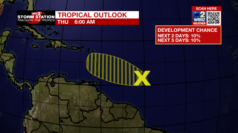
A tropical wave located over the western tropical Atlantic continues
to produce disorganized showers and thunderstorms. Only slight
additional development of this system is anticipated while it moves
west-northwestward for the next several days. The wave is forecast
to move over the Windward Islands late Friday or early Saturday and
then over the eastern Caribbean Sea by the weekend, where further
development is unlikely due to unfavorable environmental conditions.
* Formation chance through 48 hours...low...10 percent.
* Formation chance through 5 days...low...10 percent.
More News
