

Latest Weather Blog
Sunday PM Forecast: Fall pattern sticking around for the work week
Wonderful weather for the work week.
THE FORECAST
Tonight & Tomorrow: Afternoon highs today creeping in the mid-to-high 80s and we are finally starting to see some wispy cloud cover move into the area. Winds at the surface will still be coming in from the northeast, pumping cooler drier air into the area, but upper level winds have shift out of the west and now we are starting to see some light cirrus clouds in the forecast. Overnight expect to see clearing skies and temperatures falling back into the mid-50s. Monday morning will have a fall start with temperatures in the mid-50s. Dew points are still trending on the lower side which will allow for us to remain dry and comfortable in the forecast. Daytime highs are expected to reach the mid-80s again.
Up Next: Tuesday and into the rest of the work week, temperatures start to gradually rise back to around average for this time of year. Humidity starts to creep back into the forecast and we will see dew points continue to rise but conditions will still feel pretty dry. Daytime highs will be topping out in the mid-to-high-80s by next weekend. Some clouds will begin to build into the forecast as the winds start to shift. No rain in the forecast but just a little more fair weather clouds expected in the afternoons. Click here to see the 7-day forecast.
The Storm Station has you covered with hour-by-hour weather tracking is available for your location on the WBRZ WX App on your Apple or Android device. Follow WBRZ Weather on Facebook and Twitter for even more weather updates and unique weather insight from the whole team!
In the Tropics:
Trending News
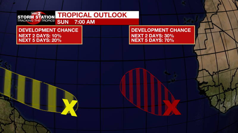
Eastern Tropical Atlantic:
An elongated area of low pressure located several hundred miles
south of the Cabo Verde Islands continues to produce disorganized
showers and thunderstorms. Environmental conditions are forecast to
be favorable for some gradual development, and a tropical
depression is likely to form around the middle part of this week.
The system is forecast to move westward, then turn northwestward
or northward by the end of the week over the eastern tropical
Atlantic.
* Formation chance through 48 hours...low...30 percent.
* Formation chance through 5 days...high...70 percent.
Central Tropical Atlantic:
Disorganized shower and thunderstorm activity continues in
association with a tropical wave located several hundred miles east
of the Windward Islands. Some gradual development of the wave is
possible during the next few days while it moves generally westward
at 15 to 20 mph, reaching the Windward Islands and the eastern
Caribbean Sea by midweek.
* Formation chance through 48 hours...low...20 percent.
* Formation chance through 5 days...low...30 percent.
More News
