

Latest Weather Blog
Sunday AM Forecast: Dry start but showers will make an apperance today
Another day of rain... Today could be the 17th straight day Baton Rouge has seen rain.
THE FORECAST
Today & Tonight: Southerly breeze already helping coastal showers form this morning. In the Capital Area we are waking up to temperatures in the mid-70s with some thin wispy clouds and plenty of moisture. As we go throughout the day temperatures will heat into the low-90s and coastal showers will begin making their way further inland during the early afternoon hours. In addition to the coastal showers, some sneaky pop-up showers are possible as well. Shower and storm activity will begin to calm down during the early evening hours. Overnight temperatures will fall back into the mid-70s and the pattern repeats for tomorrow.
Up Next: Monday rain will still be in the forecast. Waking up to Monday morning muggies and temperatures in the mid-70s. Throughout the day winds shift out of the northeast and we begin to see more showers bubbling up during the afternoon hours as storms begin to move toward the southwest. Showers and storms have the potential to produce gusty winds, heavy downpours, and frequent lightning. Radar will be calm by the evening hours, and temperatures will fall back into the mid-70s overnight. Tuesday and for the rest of your workweek, muggy start then afternoon showers is the repeating forecast for the week. All of the rain and cloud cover is holding our temperatures just below average. Click here to see the 7-day forecast.
Don’t let sneaky showers catch you off guard this weekend. Hour-by-hour weather tracking is available for your location on the WBRZ WX App on your Apple or Android device. Follow WBRZ Weather on Facebook and Twitter for even more weather updates and unique weather insight from the whole team!
Trending News
In the Tropics:
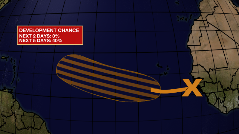
Eastern Tropical Atlantic:
A tropical wave located just off the west coast of Africa is
producing disorganized showers and thunderstorms over the far
eastern tropical Atlantic. Environmental conditions appear generally
conducive for gradual development of this system while it moves
westward to west-northwestward at 15 to 20 mph across the eastern
and central tropical Atlantic, and a tropical depression could form
around the middle part of this week.
* Formation chance through 48 hours...low...near 0 percent.
* Formation chance through 5 days...medium...40 percent.
More News
