

Latest Weather Blog
Summer steam sticks, isolated to scattered showers through weekend
The main forecast challenge through the weekend will be hitting the areal rain coverage any given day. Other than that, the typical summer pattern can be expected with heat, humidity and popping afternoon thundershowers.
Next 24 Hours: Any leftover showers will steadily diminish past dusk. A muggy night will follow with low temperatures near 73 degrees. Some early sunshine will allow high temperatures to top out near 92 degrees on Thursday with heat indices in the low 100s thanks to ample humidity. During the peak heating of the day, isolated showers and thunderstorms will pop. We are only expecting about 30 percent of the 13 Parish, 3 County Forecast Area to receive rain.
Up Next: Friday should feature more of the typical summertime weather. Though the count of showers and thunderstorms will be low, the area will not stay completely dry. Isolated, afternoon activity should develop. High temperatures will be in the low 90s. Overnight low temperatures will be in the mid 70s. Another slight uptick in showers and thunderstorms is figured into the weekend forecast thanks to a weak upper level disturbance moving across the Gulf Coast. Afternoon action will be “scattered” through at least Monday. CLICK HERE for your full 7-Day Forecast.
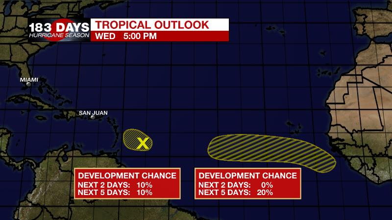
The Tropics: Recent visible satellite imagery indicates a weak area of low pressure has formed along a tropical wave located a few hundred miles east of the Windward Islands. However, shower and thunderstorm activity associated with this low is limited. Increasing upper-level winds are likely to prevent further development of this system as it moves west-northwestward at 5 to 10 mph.
Trending News
A strong tropical wave is expected to emerge off the coast of Africa over the next day or so. There is a 20 percent chance of some gradual development of this system is possible by early next week while moving generally westward over the far eastern Atlantic.
For the latest forecast and preparation reminders, visit the WBRZ Hurricane Center as we navigate all 183 Days of Hurricane Season.
The Explanation: Thursday and Friday, a ridge of high pressure centered over the Midwest will nudge over the local area leading to a bit more subsidence (sinking air) and so showers and thunderstorms should taper into the isolated or widely scattered category with primarily afternoon activity. While widespread flooding issues are not expected, warm season storms are always capable of dropping a high total in a short time over a small area. Therefore, some localized issues could develop. Otherwise, beneath this ridge, high temperatures should reach climatological normal in the low 90s and some isolated mid 90s will be possible where showers and clouds are unable to keep thermometers in check. An inverted trough will move from east to west across the central Gulf Coast states over the weekend. At the same time, an upper level trough will dig into the Lower Midwest. These features will keep an unstable air mass over the area and will lead to an increase in areal coverage of showers and thunderstorms Saturday through Monday.
--Josh
The WBRZ Weather Team is here for you, on every platform. Your weather updates can be found on News 2, wbrz.com, and the WBRZ WX App on your Apple or Android device. Follow WBRZ Weather on Facebook and Twitter for even more weather updates while you are on the go.
More News
