

Latest Weather Blog
Showers and thunderstorms ahead of weekend cool down
It didn’t last long, this won’t last long. Warm, humid conditions will hold on until a stronger cold front moves through the area early Saturday.
THE FORECAST:
Today and Tonight: Slowly but surely, moisture is returning to the atmosphere. The result will be warmth and some humidity as well as isolated showers and thunderstorms for your Thursday. Expect a high temperature near 87 degrees. Clouds will increase overnight with spotty showers and a low temperature of 73 degrees.
Up Next: A round of showers and thunderstorms is expected Friday afternoon and evening associated with a cold front. The threat for severe thunderstorms is low and this could deliver some needed rain to much of the area. A punch of crisp air will arrive for the weekend.
Trending News
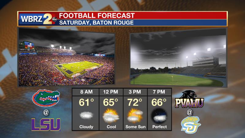
At this time, the WBRZ Weather Team expects showers to end Friday night with some lingering clouds Saturday morning followed by sun later in the day. Temperatures will be near 60 degrees at daybreak and barely sneak into the 70s during the afternoon. For LSU and Southern fans, this could mean that jackets are needed for morning tailgates and the evening games! After a cool Sunday morning, thermometers will quickly return to average for Sunday afternoon into early next week. Showers and thunderstorms will be in the forecast Monday to Wednesday ahead of the next front.
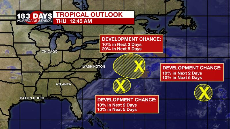
The Tropics: Overall, the Atlantic Basin is not terribly troubling at this time. An area of lower pressure off the East Coast of the United States has a 40 percent chance of tropical or subtropical development through Thursday before upper level winds become unfavorable. Another system well east of Bermuda is given a 40 percent chance of development before conditions become too harsh.
THE EXPLANATION:
By Thursday, enough moisture will be established to make it feel more humid and even generate isolated showers and thunderstorms. A strong storm system will move across the nation on Friday. For the local area, an approaching cold front will force showers and thunderstorms to develop. Instability will be high enough to support thunderstorms but a lack of wind shear should keep them from turning severe. Frontal passage is expected to occur overnight Friday into Saturday. Timing of this boundary is important to the forecast. Should the front pass at night as it currently expected, showers will end before daybreak with a morning temperature in the 50s or 60s, followed by clearing skies and an afternoon temperature in the 70s. If the front slows at all, some showers could linger into the first half of Saturday with an early high in the 70s and steady or falling temperatures into the 60s for the afternoon. Again, this spell will be short with a return to above normal temperatures by Sunday afternoon into early next week. A few weak, fast moving systems could spread some showers across the area Monday and Tuesday. Another cold front will sweep across the region on Wednesday.
--Josh
The WBRZ Weather Team is here for you, on every platform. Your weather updates can be found on News 2, wbrz.com, and the WBRZ WX App. on Apple and Android devices. Follow WBRZ Weather on Facebook and Twitter for even more weather updates while you are on the go.
More News
