

Latest Weather Blog
Rainy pattern continues for the first half of the week
Monday is the start of a rainy pattern for the first half of the week.
THE FORECAST
Tonight & Tomorrow: An initial line of storms came through the area overnight, and now as a boundary stalls out over south Louisiana, a few more rounds of rain are expected this morning. A Flash Flood Watch remains active through noon today. Look out for poor drainage flooding as some areas will get brief downpours. Temperatures between the showers will be in the low 80s.
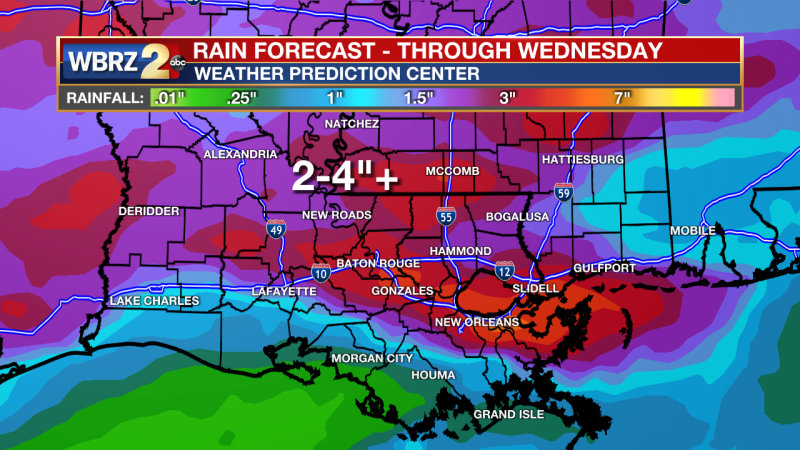
Up Next: The stalled out front will stay over our area through parts of Thursday. This means the thick could cover and gloomy conditions will stick around. Tuesday morning will start out muggy with temperatures near 70 degrees. Showers will be possible all day long, but they will be light and on and off. Tuesday afternoon temperatures will be in the low 80s. With all the cloud cover continuing into Wednesday, temperatures will be capped in the 70s. Showers will be on and off all day Wednesday and into Thursday morning, then the boundary will make a final push to the south and we will dry out heading into the weekend. When everything is said and done, rainfall totals will be between 2-4 inches with isolated higher amounts possible. Friday will start us on a totally new weather story. Temperatures will be in the low 80s with mostly sunny skies through Sunday. Click here to see the 7-day forecast.
Trending News
Get right now weather conditions for your location on the WBRZ WX App on your Apple or Android device. Follow WBRZ Weather on Facebook and Twitter for even more weather updates and unique weather insight from the whole team!
More News
