

Latest Weather Blog
Monday PM Forecast: Summer preview to end abruptly as next cold front arrives
Heat will continue to dominate on Tuesday as highs near 90° for the second straight day. However, a looming cold front is set to flip the script, bringing several rounds of rain and significantly cooler temperatures by the end of the week.
Tonight & Tomorrow: After reaching 90° for the first time this year on Monday, the Capital Area is facing a very warm and muggy night ahead. A mostly clear evening sky will gradually turn cloudy overnight, with lows settling in the lower 70s. Gray skies initially will eventually turn partly sunny as the day wears on. The boost in sunshine, in tandem with a ridge of high pressure, will push highs to around 90° for the second straight day. This means that Tuesday’s record high of 90° in Baton Rouge is in jeopardy.
Humidity will drive the heat index, or feels-like temperature, into the lower and middle 90s by peak warming. The human body needs a week or two to adjust to this kind of heat, so this serves as a reminder to drink plenty of water and take it a little easier outside.

Up Next: A change in pattern comes on Wednesday with the arrival of a cold front. The front will not only drive up rain chances, but also allow temperatures to crash by the end of the week.
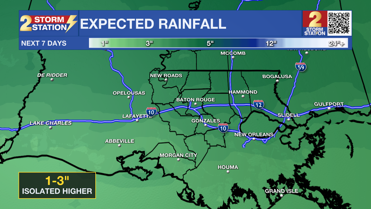
Wetter Weather Ahead – Guided by a cold front, isolated showers and thunderstorms will move in from the north as early as Wednesday afternoon. A few could be strong, capable of large hail and gusty winds. Off-and-on storms will persist through the night and into Thursday as the front continues to progress through the region. Friday will see occasional showers before a more organized shield of heavy rain comes on Friday night and into Saturday. This uptick in activity comes as a coastal disturbance develops, potentially leading to a soggy start to the weekend. Stay in touch with the Storm Station as the timing becomes clearer. All told, anywhere from 1-3” of rain is expected over the next week, with narrow corridors accumulating higher amounts.
Trending News
Big Temperature Drop – Just ahead of the cold front, temperatures will peak in the upper 80s on Wednesday. Highs will stair-step down through the rest of the week: reaching the lower 80s on Thursday, the 70s on Friday, and a mix of 60s and 70s by Saturday. Overnight lows will come down too, reaching the 50s by the weekend. Temperatures will slowly recover Sunday onward, as rain dries up in the forecast.

Get the latest 7-day forecast and real-time weather updates HERE.
Watch live news HERE.
— Meteorologist Malcolm Byron
The Storm Station is here for you, on every platform. Your weather updates can be found on News 2, wbrz.com, and the WBRZ WX App on your Apple or Android device. Follow WBRZ Weather on Facebook and X for even more weather updates while you are on the go.
More News
