

Latest Weather Blog
Midday showers and storms, a few could be strong
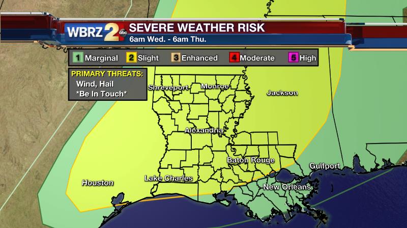
The Storm Prediction Center has included much of the WBRZ Weather forecast area in a “slight risk” for severe storms on Wednesday. Gusty wind and hail are the main threats. Carry on with the day as usual; just keep your severe weather safety plan in mind and stay in touch with the forecast. Our weather team will let you know if any watches or warnings are issued.
THE FORECAST:
Today and Tonight: Expect a line of showers and thunderstorms to cross the area between 10am – 2pm, with only isolated activity otherwise. Should the line of storms develop some breaks, it is feasible that a small area misses out on rain today, but most will get something. While temperatures will fall as it rains, some returning sunshine this afternoon should still allow a high temperature in the low to mid 80s. Overnight, a few showers may continue on, with low temperatures sticking in the upper 60s.
Up Next: Showers and thunderstorms will again be more isolated on Thursday—especially during the first half of the day. Again, no washout is in the cards and some sun is expected before and after any showers. High temperatures will climb into the mid 80s. A warm and humid feel will continue into Friday and Saturday with high temperatures in the upper 80s and far fewer showers in the area. By Sunday, a storm system is expected to bring more widespread rain.
Trending News
THE SCIENCE:
Forecast Discussion: A negatively titled trough lifting northeastward through the Midwest and weakening will have enough momentum to send a squall line toward the Gulf Coast today. This feature will move into an unstable and moist environment. High resolution models are timing the squall line out for midday; some as early as 10am, others as late as noon. While uplift will be modest, the line itself should be able to sustain showers and thunderstorms feeding off of the environment alone. While widespread severe weather is not expected, some gusty wind, hail and downpours will be possible with any of the storms. The SPC has included areas along and north of I-10 in a “slight risk” for severe storms and this seems appropriate. Measurable rain coverage in the 13 Parish, 3 County forecast area is expected to be up compared to the isolated showers noted over the last two days—on the order of 60%. Isolated showers and thunderstorms will hang on Thursday in the presence of a weak leftover boundary. By Friday, a weak mid-level ridge will bring more of a lid over the region capping off much, if not all, of the convection. Another shortwave, positioned farther south will work into the region by Sunday. An accompanying surface low and front are expected to help develop more widespread showers and thunderstorms for the second half of the weekend. Slow-moving, this trough could send waves of rain toward the local area with a few inches accumulating between Sunday and Tuesday.
For updates, stay connected with Meteorologist Josh Eachus:
More News
