

Latest Weather Blog
FLASH FLOOD WATCH in effect until Saturday Night
Today and Tonight: Periods of rain and thunderstorms will dampen the Baton Rouge area Thursday. Where particularly heavy bands of rain set up, several inches could fall and create flash flooding. A general 1-3” of liquid will fall everywhere else. Temperatures won’t get out of the middle 70s on account of daylong cloud cover and precipitation. Rounds of rain, some heavy, will continue tonight, with a low in the upper 60s.
A FLASH FLOOD WATCH means conditions are favorable in the atmosphere to where heavy rain is possible. Stay alert to the weather and think about where you would go if water begins to rise. A WARNING means flash flooding is occurring or imminent. To remain safe, you can move away from rising or rishing water. Look out for water covered roads and don't drive over them. Click here for more flash flood safety.
Up Next: Heavy rain and thunderstorms are expected to continue on Friday. Again, 1-3” of precipitation will be possible. In addition to flash flooding, a coastal flood advisory is in place as the combination of heavy rain and southerly winds will keep runoff from readily draining into Lake Pontchartrain and Lake Maurepas. Backwater flooding in the typical trouble spots could be an issue. Temperatures will be in the mid 70s. Friday Night into Saturday, the heaviest rain should begin to pull away eastward as temperatures fall into the low 60s. Still, some shower activity may linger into the first half of Saturday with rain ending from west to east through the day. We will be keeping a close eye on the trends as they may affect the St. Patrick’s Day Parade. Overall storm totals of 5-8” are anticipated.
THE SCIENCE:
Trending News
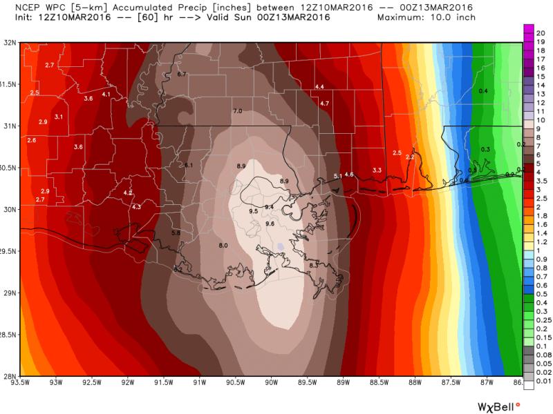
Forecast Discussion: The parent upper low remains parked over South Texas with a quasi-stationary surface low and associated fronts in Southeast Texas. Precipitable water values over 2” and 200-300% of normal for this time of year will mean any thunderstorms can be very efficient rain makers. A unidirectional jet stream and moisture convergence will allow the possibility of training thunderstorms which could produce continuous bands of heavy rain. Helicity values remain somewhat elevated, telling us that one or two storms could still kick out gusty wind or a brief tornado. The cut-off upper low will begin to eject northeastward on Friday, sending a pocket of high positive vorticity advection and omega (uplift) across the forecast area. This energy should continue to enhance rain development through the day. Over the 48 hour span flash flooding will be possible in locations that pick up excessive amounts a short period of time. By Saturday, the upper low will pull away to the east with a final push of rain and thunderstorms along the associated surface front. As the entire storm complex exits Saturday Night, skies will clear, the air mass will dry and spring-like weather returns Sunday through Tuesday. High temperatures will approach 80 degrees as a id-level ridge moves overhead and turns the pattern (briefly) quiet.
--Josh
Twitter: @Josh_Eachus
Google+: Josh Eachus
Facebook: Meteorologist Josh Eachus
More News
