

Latest Weather Blog
Few showers to dodge over the weekend
The weekend forecast will include some rain chances, but do not expect either day to be a washout. Much warmer temperatures are anticipated next week.
THE FORECAST:
Today and Tonight: The week will end with highs returning to the 80s and increasing clouds. While a spotty shower is possible, chances for anything measurable are very low. Southeast winds will keep temperatures mild overnight with lows in the mid 60s. Skies will stay mostly cloudy.
Up Next: A weak front will stall in western Louisiana by Saturday and a modest upper level disturbance will roll over that front to kick out a few showers and thunderstorms, especially west of the Mississippi River. In the absence of upper level energy, rain chances will go down on Sunday. The weak front will not push through the local area and therefore, temperatures will continue to warm into early next week allowing some thermometers to take another run at 90 by Tuesday or Wednesday. In step with this thinking, the Climate Prediction Center is showing a high probability of above average temperatures.
Trending News
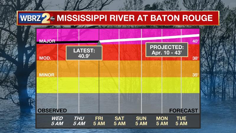
The Mississippi River: At Baton Rouge, major flood stage continues with a level of 41’ as of Friday morning. Around April 10, the river is projected to crest near 43’. The high water is primarily an issue for river traffic and river islands, although some inundation will continue for a few spots north and south of Baton Rouge that are not protected by levees. Unprotected low-lying areas will be flooded and agricultural operations will be impacted on the west side of the river. The grounds of the older part of Louisiana State University's campus become soggy. This includes the area around the Veterinary Medicine building, the Veterinary Medicine Annex, the stadium and ball fields. The city of Baton Rouge and the main LSU campus are protected by levees at this level. This comes after a year where the gauge at Baton Rouge spent a record smashing run of 212 consecutive days above flood stage between January and August. Peaking at 44.1’ on March 19, 2019 the river set its 7th highest recorded crest at Baton Rouge. The level is also high in New Orleans As the U.S. Army Corps of Engineers will open the Bonnet Carre Spillway on Friday. From May to July 2019, the Spillway was open for a record 79 consecutive days during its second opening of the year. If the Spillway is opened in 2020, it will mark the fourth time in five years and the 15th time since being built in 1931.
THE EXPLANATION:
On Friday, an upper level ridge will be centered east of the area, but likely still exert enough influence that a cold front over eastern Texas will be too far away to bring lift to generate showers. On Saturday, the front will push toward Louisiana as an upper level disturbance moves overhead. This combination should be sufficient to produce scattered showers and thunderstorms in the afternoon and evening hours. By Sunday, the upper level ridge will build back over the forecast area creating sinking air and mitigating precipitation development. Monday through Wednesday, the ridge will be anchored overhead leading to well above average temperatures that could challenge 90 degrees and some records. However, we may also find southerly winds aiding in typical warm season marine breeze convective processes—that is, isolated afternoon showers and thunderstorms.
--Josh
The WBRZ Weather Team is here for you, on every platform. Your weather updates can be found on News 2, wbrz.com, and the WBRZ WX App. on Apple and Android devices. Follow WBRZ Weather on Facebook and Twitter for even more weather updates while you are on the go.
More News
