

Latest Weather Blog
A new rainmaker will move in to shake up the weather pattern this weekend, Watching the tropics
A cold front will be the rainmaker for the holiday weekend.
THE FORECAST
Today & Tonight: The pattern repeats again today. Temperatures will warm into the mid to upper 80s and some thick cloud cover along with a few showers will keep us out of the 90s. The heat index however will climb into the mid 90s. About half of the viewing area, 50%, will see showers today. The most active time will be between 11am-3pm. The overnight hours will be dry with temperatures in the 70s.
Up Next: On Thursday, rain coverage will be near 40% of the area. When it’s not raining, temperatures will be in the upper 80s, but the heat index will likely stay out of the triple digits. Although rain is in the forecast each afternoon, not everyone will see rain, and you should be able to find a few dry hours for yard work. Track out live radar for your location on the WBRZ WX App, and you can even set alerts for heavy rain! Download here.
Looking ahead to the weekend, a large cold front is going to drape over most of the US. It will slowly move from north to south concentrating all the available moisture over the Gulf Coast. The front will likely dissipate before reaching the area, so instead of cooling things off, it will be a rainmaker for the area on Friday, Saturday and Sunday. The afternoon hours look to be the most active with widespread showers that will die down later in the evening. Stay with us all week for new forecast details for the holiday weekend. Click here to see the 7-day forecast.
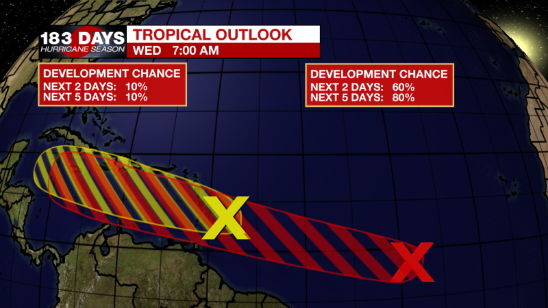
In the Tropics: There are two disturbances in the Atlantic, but only one is likely to organize into a tropical depression. The red ‘X’ is the location of a tropical wave with a high chance of organizing in the next two days. It is moving near 20 mph west toward the Leeward and Windward Islands. Right now, it is too early to know the potential strength or path of this storm. The tropics are not impacting the local 7-day forecast at this time. Stay with us for timely updates. Click here to visit the WBRZ Hurricane Center.
Trending News
Need weather conditions HOUR BY HOUR? Get hour by hour weather and right now weather conditions for your location on the WBRZ WX App on your Apple or Android device. Follow WBRZ Weather on Facebook and Twitter for even more weather updates and unique weather insight from the whole team!
More News
