Wednesday evening video forecast
Related Story
The weather doldrums continue. At least, Tropical Storm Fred is still not expected to directly affect the local area.
The Tropics: As of 4pm Wednesday, Tropical Storm Fred was moving west-northwest at 15mph over the Dominican Republic with maximum winds of 40mph. Fred will continue on the same general track but slow down over the next two days and move near the northern coast of Cuba by Friday. Fred is expected to weaken to a depression tonight as it crosses Hispaniola. Slow re-intensification is expected beginning Thursday night. After that, the storm will turn northwest into the Gulf of Mexico, parallel the Florida Peninsula, and re-strengthen into a tropical storm. Landfall is expected to occur in the Florida Panhandle sometime on Monday.

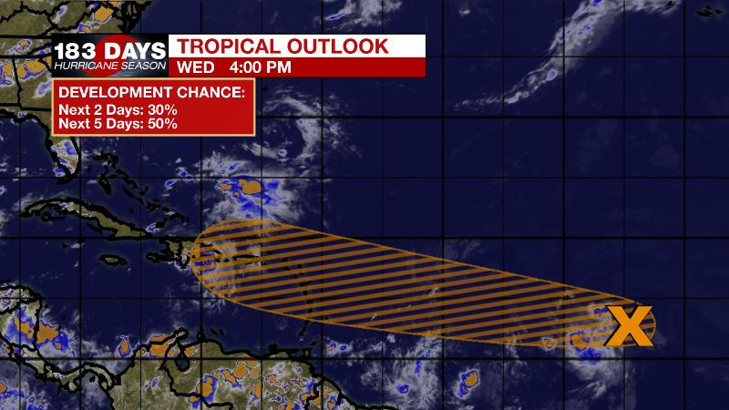
Another tropical wave located over the eastern tropical Atlantic continues to produce disorganized showers and thunderstorms. Environmental conditions allow a 50 percent chance of development over the next five days while this wave move westward across the ocean.
For the latest tropical forecasts, advisories and information, visit the WBRZ Hurricane Center as we navigate all 183 Days of Hurricane Season.
Next 24 Hours: All showers will fizzle by 10pm with partial clearing in skies. Low temperatures will stop around 74 degrees. Rinse and repeat on Thursday with morning sunshine giving way to scattered, afternoon showers and thunderstorms, primarily between 12pm – 6pm. High temperatures will top out near 90 degrees.
Up Next: Scattered, afternoon showers and thunderstorms will remain common into the weekend. For the 13 Parish, 3 County Forecast Area, rain coverage will be around 40 to 60 percent Friday through Sunday. As for temperatures, highs will be near 91 with lows near 75. Monday and Tuesday will likely feature a bit more activity due to an upper level trough adding more instability to the atmosphere. With plenty of moisture in the atmosphere as well, scattered to widespread showers and thunderstorms are anticipated. One or two storms could cause minor flooding. CLICK HERE for your full 7-Day Forecast.
The Explanation: Atmospheric moisture will climb through the end of the week and will combine with seasonable heat and humidity to generate afternoon showers and thunderstorms to develop. Additionally, that humidity will combine with midday high temperatures in the low 90s to produce feels-like temperatures near 105 degrees early each afternoon. Saturday through Tuesday, the pattern will be similar to the previous couple of days with a few subtle changes. Ongoing southeasterly wind flow will add even more moisture to the atmosphere, which will lead to an uptick in the number of showers and thunderstorms that can develop. Another consequence of the added moisture is that some thunderstorms could dump torrential rain in a short time. There could be some isolated instances of street and poor drainage flooding. These warm season storms can always produce frequent lightning and gusty wind as well. Tropical Storm Fred continues to be an item to watch for the local forecast, although it still does not appear to play a major role in our weather. It is currently forecast to make landfall along the northeastern Gulf Coast by early next week as a tropical storm. Regardless of this system, we are steadily approaching the peak of hurricane season, so continue to monitor with us and have a plan in place for in case one comes our way.
--Josh
The WBRZ Weather Team is here for you, on every platform. Your weather updates can be found on News 2, wbrz.com, and the WBRZ WX App on your Apple or Android device. Follow WBRZ Weather on Facebook and Twitter for even more weather updates while you are on the go.


