

Latest Weather Blog
Wednesday PM Weather: turning drier, turning hotter
Expect one more “active” day in terms of showers and thunderstorms. Higher heat will be the story to follow.
Next 24 Hours: With low temperatures around 74 degrees once again, tonight will be partly cloudy with spotty showers possible. Thursday will be one last “hoorah” for the scattered showers and thunderstorms. In fact, a bit more activity is expected tomorrow when compared with previous days and showers and thunderstorms could fire as early as daybreak. Any thunderstorms will be capable of brief downpours, frequent lightning and gusty wind. Added showers and clouds will cause many locations to stop at 90 degrees or perhaps even in the upper 80s.
Up Next: An upper level ridge of high pressure will build over the central Gulf Coast Friday through Monday. This system will shield the local area from Hurricane Grace, but also cause slightly drier and warmer weather. Through Monday, rain coverage in the 13 Parish, 3 County Forecast Area will stay at 20 percent or less—and that may be generous. Highs will reach the mid 90s with feels-like temperatures over 105 degrees for several hours each day. Lows will stay in the mid to upper 70s. Another round of HEAT ADVISORIES may be needed. CLICK HERE for your full 7-Day Forecast.
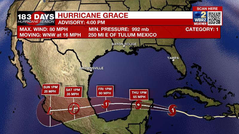
The Tropics: As of 4pm Wednesday, Hurricane Grace was 250 miles east of the Yucatan Peninsula. The storm had maximum sustained winds at 80mph, moving to the west-northwest at 15mph. This general motion or a more due west track will occur over the next few days as Grace strengthens slightly. Hurricane Warnings have been posted for the Yucatan Peninsula. Grace will remain well south of the central Gulf Coast, crossing the southern Gulf of Mexico and reach central Mexico over the weekend.
Trending News
?? FOR THE UNUSUAL FILE
— Josh Eachus (@DrJoshWX) August 18, 2021
Major northeast cities like New York, Boston in "the cone" of a soon-to-be hurricane. The last hurricane landfall in this region, was Sandy in 2012. #Henri pic.twitter.com/KS4gjzrcdk
As of 4pm Wednesday, Tropical Storm Henri was getting better organized south of Bermuda with maximum sustained winds of 70mph and a west motion at 9mph. Henri will speed up while circling west of Bermuda as a hurricane. The newest track, takes Henri close and possible into the Northeast U.S.
For the latest tropical forecasts, advisories and information, visit the WBRZ Hurricane Center as we navigate all 183 Days of Hurricane Season.
The Explanation: Typical August weather is expected for one more day. A subtle, weak upper level trough will exist just west of the area due to a building upper level ridge in the Mid-Atlantic. An upper level impulse or two could ride over the local area to enhance the development of showers and thunderstorms from daybreak into the late afternoon hours of Thursday. As you might expect, while severe weather is not anticipated, any thunderstorms will be capable of brief downpours and frequent lightning. By Friday, an upper level ridge will build across the region. The effects of this ridge will be two-fold. First, and more importantly, the clockwise circulation around the ridge will steer Tropical Storm Grace from east to west across the southern Gulf of Mexico, away from the local area. Therefore, no impacts are expected from that system. Second, the ridge will cause subsidence, or sinking air, will serves to suppress convection and cause even more warming. With humidity not going anywhere, the heat index will have no problem reaching the 105 – 110 range Friday through Monday as air temperatures peak in the mid 90s. This may cause the National Weather Service to issue Heat Advisories once again. Friday and Saturday should feature a rather dry atmosphere and rain will be tough to find. A little bit more moisture may be found in the atmosphere on Sunday and Monday for isolated, afternoon showers and thunderstorms to develop. The bottom line is, it is difficult to guarantee completely dry conditions across the area with all the instability along the Gulf Coast this time of year, but daily rain coverage will be much lower than usual.
--Josh
The WBRZ Weather Team is here for you, on every platform. Your weather updates can be found on News 2, wbrz.com, and the WBRZ WX App on your Apple or Android device. Follow WBRZ Weather on Facebook and Twitter for even more weather updates while you are on the go.
More News
