

Latest Weather Blog
Wednesday AM Forecast: Get outside and enjoy the sunshine before rain returns this weekend
Get your yardwork done before Friday. Showers will be back before you know it!
THE FORECAST
Today & Tonight: Today is the start of a short dry pattern. There is some patchy fog out there this morning, but it will start to break up as the sun comes up. Skies will be mostly clear, and temperatures will hit the low to mid 90s. Just a few showers will be around this afternoon with most locations staying dry. Slightly lower humidity will settle in tonight with temperatures in the low 70s.
Don't wait for the weekend to mow the lawn! Widespread rain will be back before you know it... I am going to Saturday and Sunday red flags. pic.twitter.com/AI1ynZoxXJ
— Marisa Nuzzo WBRZ (@marisanuzzowx) August 31, 2022
Up Next: Thursday will be the driest day of the week with most of the shower activity bubbling up along the coastline. Temperatures will be in the mid-90s with the heat index near 100°. Heading into the weekend, rain coverage will spike back up. Friday afternoon will bring scattered showers with the majority of the area seeing rain. Saturday and Sunday will have widespread showers too. Of the two days, Saturday looks like more of a washout. Rainfall totals for the next 7 days are expected to be 2-4 inches. This is manageable over several days. There may be isolated areas that receive rain at a rate faster than the drains can handle. Stay weather aware and check current conditions before hitting the road. Click here to see the 7-day forecast.
Trending News
Use the WBRZ WX App to stay ahead of the afternoon showers and storms. Hour-by-hour weather tracking is available for your location on the WBRZ WX App on your Apple or Android device. Follow WBRZ Weather on Facebook and Twitter for even more weather updates and unique weather insight from the whole team!
In the Tropics
There are now three disturbances in the Atlantic that may develop in the next week. They are not a threat to the local area.
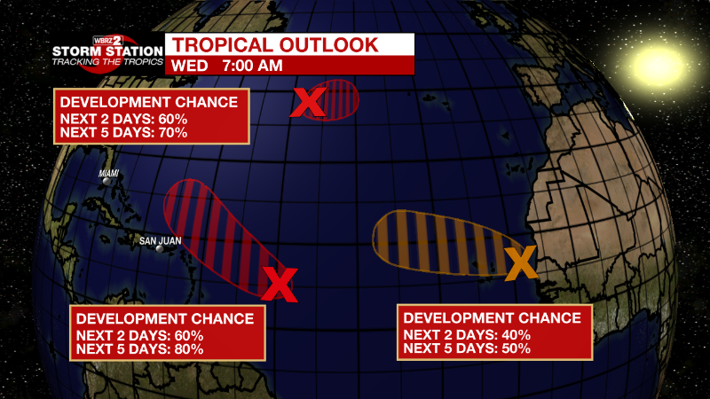
Central Tropical Atlantic: Shower and thunderstorm activity associated with an area of low pressure located several hundred miles east of the Lesser Antilles has changed little this morning. Although environmental conditions are only marginally conducive, additional gradual development of this system is expected and a tropical depression is likely to form within the next couple of days. The disturbance is forecast to move slowly toward the west-northwest, toward the adjacent waters of the northern Leeward Islands. Additional information on this system can be found in High Seas Forecasts issued by the National Weather Service.
* Formation chance through 48 hours...medium...60 percent.
* Formation chance through 5 days...high...80 percent.
Eastern Tropical Atlantic: Showers and thunderstorms associated with a broad area of low pressure located between the west coast of Africa and the Cabo Verde Islands have become slightly better organized. Some gradual development is possible, and the system could become a short-lived tropical depression over the far eastern Atlantic during
the next couple of days. By late this week, environmental conditions are forecast to become increasingly unfavorable for further development. Regardless, the system could bring locally heavy rainfall to portions of the Cabo Verde Islands through Thursday.
* Formation chance through 48 hours...medium...40 percent.
* Formation chance through 5 days...medium...50 percent.
Central Subtropical Atlantic: An area of low pressure has formed along a decaying frontal zone over the central subtropical Atlantic about 850 miles west-southwest of the westernmost Azores. Environmental conditions are expected to be conducive for development, and a tropical or subtropical depression is likely to form during the next few days while the system drifts generally eastward.
* Formation chance through 48 hours...medium...60 percent.
* Formation chance through 5 days...high...70 percent.
More News
