

Latest Weather Blog
UPDATE: Some rivers to remain in flood stage until Thursday
BATON ROUGE – Many river systems near the Capital City remain in major flood stage Sunday after thunderstorms brought record rainfall to the area this week. While the Tickfaw River has already crested, the Amite River is expected to rise in some areas until it crests as late as Tuesday
Below are river level forecasts from the National Weather Service: (Note: As with any weather forecast, this information is subject to change. Stay tuned to WBRZ News 2 for updates as more information becomes available).
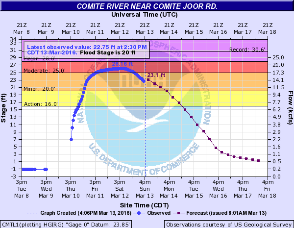
The Comite River near Joor Road crested at 4:30 p.m. Saturday afternoon at 26.16 feet. The river will remain in minor flood stage until Monday afternoon. Subdivisions between the Comite River and Beaver Bayou are expected to have moderate flooding until Monday morning.
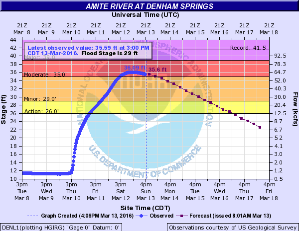
The Amite River near Denham Springs crested early Sunday morning at 36.09 ft. Sunday morning. The river will remain in moderate flood stage until Monday morning. The NWS predicts possible flooding around Clay Cut Bayou, Jones Creek and Honey Cut Bayou until Sunday evening. Also, areas in Denham Springs west of Florida Avenue will be subject to flooding until Sunday evening.
Trending News
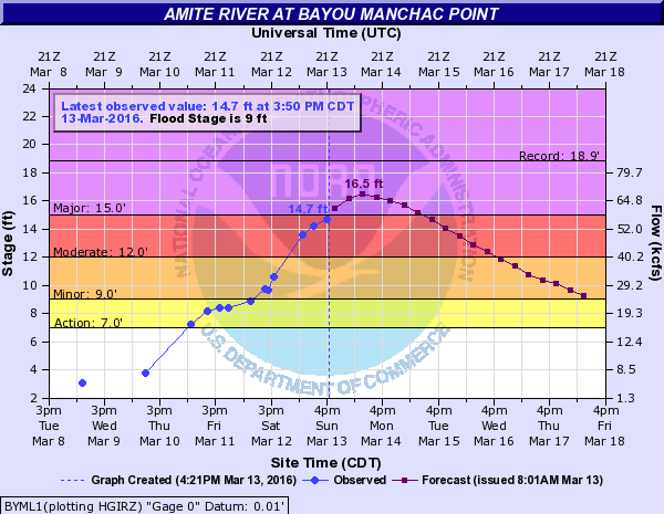
Downstream at Bayou Manchac, the Amite River is expected to reach major flood stage Monday night. The river is expected to crest at 16.5 ft. Monday morning. The Amite River will remain in major flood stage until Tuesday morning.
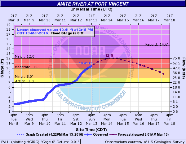
Near Port Vincent, the Amite River is expected to reach major flood stage Monday afternoon. The river is expected to crest at 12 ft. and will remain in major flood stage until Tuesday morning. Expect minor flooding to residential areas.
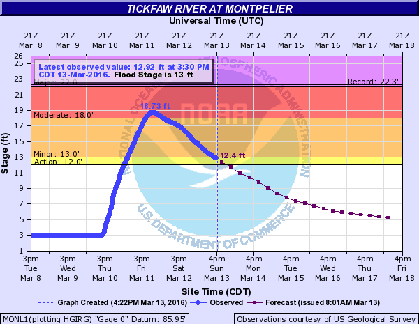
The Tickfaw River has crested, but is expected to remain in moderate flood stage at Holden until Monday morning. In Montpelier, the Tickfaw River is dropping dramatically is below flood stage.
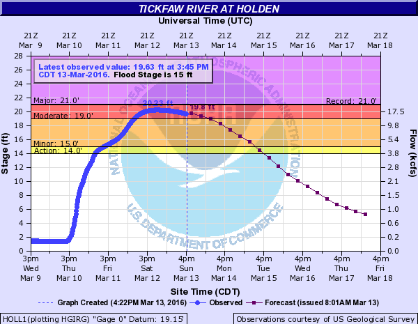
Downstream at Holden, the Tickfaw River is crested just short of the record of 21 ft. set in 1983. The river will remain in moderate flood stage until Monday morning. Property in low areas along the river from I-12 to Parish Road 1036 will likely remain flooded until Monday morning.
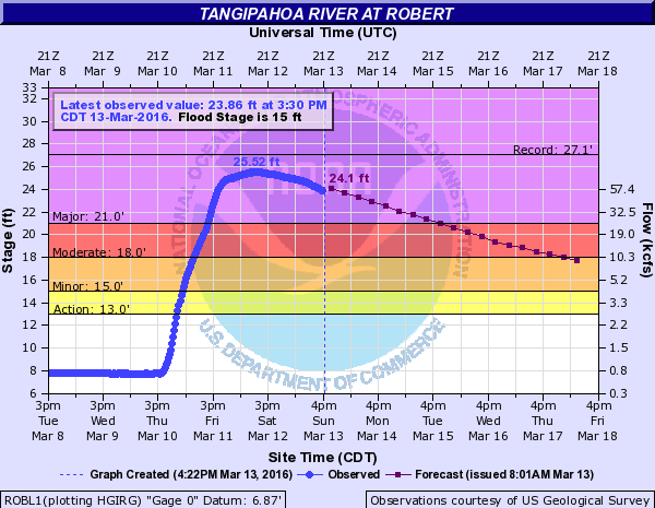
In Robert, the Tangipahoa River has already crested at 25.54 ft. but will remain in major flood stage until Tuesdayevening.
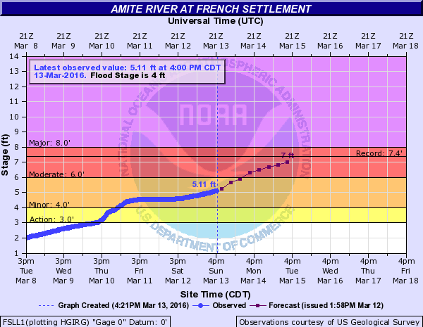
The NWS forecasts that the Amite River will reach 7.0 ft. by Tuesday afternoon at French Settlement. It is possible that flooding could cause La. Hwy 16 to close near Port Vincent and the Louisiana Trace will be impassable. Note: At the time of writing, the National Weather Service forecast only extends until 1 p.m. Tuesday for the French Settlement area. Click here to see the updated NWS information.
For more information, or data from locations not listed in this story, visit the National Weather Service Website by clicking here.
This is a developing story. Stay tuned to WBRZ Weather online and on Facebook and Twitter for updates as new information becomes available. River stages will be updated through the evening on the WBRZ News 2 24-hour weather channel.
Related Stories
More News
